Batesburg-Leesville geodata
Batesburg-Leesville (South Carolina) is a populated place; located in United States in America/New_York (GMT-4) time zone. With population of 5,441 people, there are 6812 cities with bigger population in this country. Compared to other cities in United States, 80.9% of cities are located further ↑North; 67.4% of cities are located further ←West and 50% of cities have lower elevation than Batesburg-Leesville. Note1


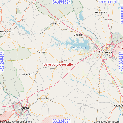
Batesburg-Leesville GPS coordinates[2]
33° 54' 36.504" North, 81° 32' 14.388" West
| Map corner | latitude | longitude |
|---|---|---|
| Upper-left | 34.49167°, | -82.24046° |
| Center: | 33.91014°, | -81.53733° |
| Lower-right: | 33.32462°, | -80.83421° |
| Map W x H: | 129.8×129.8 km | = 80.7×80.7mi |
| max Lat: | 71.29058° ⇑80.9% North |
| Batesburg-Leesville: | 33.91014° |
| min Lat: | ⇓19.1% South 19.06759° |
| min Long | Batesburg-Leesv | max Long |
| -171.73463° | -81.53733° | -66.98998° |
| W 67.4%⇐ | ⇒32.6% E |
Elevation
Elevation of Batesburg-Leesville is 198 m = 650 ft, and this is 96.8 m = 318 ft below average elevation for this country.
| Max E: |
3189 m = 10463 ft | 50% |
| Avg. | 294.8 m = 967 ft | |
| Batesburg-Leesville | 198 m = 650 ft | |
Min E: |
-60 m = -197 ft | 50% |
See also: United States elevation on elevation.city.
Geographical zone
Batesburg-Leesville is located in North temperate zone (between Tropic of Cancer and the Arctic Circle). Distance of this Northern Tropic circle is 1164.5 km =723.6 mi to South.| Distance of | km | miles | from Batesburg-Leesville |
|---|---|---|---|
| North Pole | 6236.6 | 3875.2 | to North |
| Arctic Circle | 3630.7 | 2256 | to North |
| Tropic Cancer | 1164.5 | 723.6 | to South |
| Equator | 3770.5 | 2342.9 | to South |


Nearby cities:
15 places around Batesburg-Leesville: (largest is in red/bold)
• Batesburg
1 km =0.6 mi,  255°
255°
• Chapin
33.3 km =20.7 mi,  31°
31°
• Gilbert
13.3 km =8.3 mi,  83°
83°
• Johnston
25.8 km =16 mi,  250°
250°
• Lake Murray of Richland
34.3 km =21.3 mi,  47°
47°
• Leesville
2.3 km =1.4 mi,  72°
72°
• Lexington
28.9 km =18 mi, 74°
• Oak Grove
37.2 km =23.1 mi, 77°
• Pelion
31.6 km =19.6 mi,  121°
121°
• Prosperity
33.3 km =20.7 mi,  0°
0°
• Red Bank
27.7 km =17.2 mi, 84°
• Ridge Spring
13.6 km =8.5 mi,  237°
237°
• Saluda
23.9 km =14.9 mi,  295°
295°
• South Congaree
37.1 km =23.1 mi,  89°
89°
• Wagener
33 km =20.5 mi,  150°
150°
Sources, notices
• [Note1] Compared only with cities in United States existing in our database
• [Src1] Map data: © OpenStreetMap contributors (CC-BY-SA)
• [Src2] Other city data from geonames.org with taken over terms of usage.
• [Src3] Geographical zone / Annual Mean Temperature by Robert A. Rohde @ Wikipedia
