Oak Grove geodata
Oak Grove (South Carolina) is a populated place; located in United States in America/New_York (GMT-4) time zone. With population of 10,291 people, there are 4375 cities with bigger population in this country. Compared to other cities in United States, 80.4% of cities are located further ↑North; 69% of cities are located further ←West and 68.3% of cities have higher elevation than Oak Grove. Note1


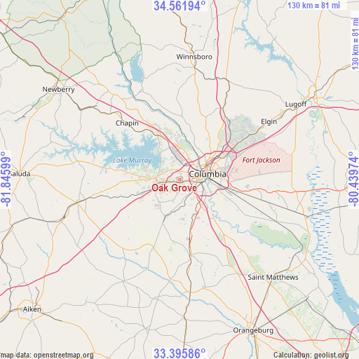
Oak Grove GPS coordinates[2]
33° 58' 51.24" North, 81° 8' 34.296" West
| Map corner | latitude | longitude |
|---|---|---|
| Upper-left | 34.56194°, | -81.84599° |
| Center: | 33.9809°, | -81.14286° |
| Lower-right: | 33.39586°, | -80.43974° |
| Map W x H: | 129.7×129.7 km | = 80.6×80.6mi |
| max Lat: | 71.29058° ⇑80.4% North |
| Oak Grove: | 33.9809° |
| min Lat: | ⇓19.6% South 19.06759° |
| min Long | Oak Grove | max Long |
| -171.73463° | -81.14286° | -66.98998° |
| W 69%⇐ | ⇒31% E |
Elevation
Elevation of Oak Grove is 111 m = 364 ft, and this is 183.8 m = 603 ft below average elevation for this country.
| Max E: |
3189 m = 10463 ft | 68.3% |
| Avg. | 294.8 m = 967 ft | |
| Oak Grove | 111 m = 364 ft | |
Min E: |
-60 m = -197 ft | 31.7% |
See also: United States elevation on elevation.city.
Geographical zone
Oak Grove is located in North temperate zone (between Tropic of Cancer and the Arctic Circle). Distance of this Northern Tropic circle is 1172.4 km =728.5 mi to South.| Distance of | km | miles | from Oak Grove |
|---|---|---|---|
| North Pole | 6228.7 | 3870.3 | to North |
| Arctic Circle | 3622.9 | 2251.2 | to North |
| Tropic Cancer | 1172.4 | 728.5 | to South |
| Equator | 3778.3 | 2347.7 | to South |


Nearby cities:
15 places around Oak Grove: (largest is in red/bold)
• Arcadia Lakes
18.6 km =11.6 mi,  64°
64°
• Cayce
6.6 km =4.1 mi,  104°
104°
• Columbia
10.2 km =6.3 mi,  77°
77°
• Forest Acres
14.7 km =9.1 mi,  73°
73°
• Gaston
18.6 km =11.6 mi,  168°
168°
• Irmo
12.3 km =7.6 mi,  342°
342°
• Lake Murray of Richland
19.1 km =11.9 mi,  324°
324°
• Lexington
8.6 km =5.3 mi,  270°
270°
• Pineridge
8.6 km =5.3 mi,  155°
155°
• Red Bank
10.4 km =6.5 mi,  238°
238°
• Saint Andrews
7.3 km =4.5 mi,  9°
9°
• Seven Oaks
7.6 km =4.7 mi,  357°
357°
• South Congaree
7.8 km =4.8 mi,  175°
175°
• Springdale
3.9 km =2.4 mi,  127°
127°
• West Columbia
6.5 km =4 mi, 77°
Sources, notices
• [Note1] Compared only with cities in United States existing in our database
• [Src1] Map data: © OpenStreetMap contributors (CC-BY-SA)
• [Src2] Other city data from geonames.org with taken over terms of usage.
• [Src3] Geographical zone / Annual Mean Temperature by Robert A. Rohde @ Wikipedia
