Saluda geodata
Saluda (South Carolina) is a seat of a second-order administrative division; located in United States in America/New_York (GMT-4) time zone. With population of 3,596 people, there are 8728 cities with bigger population in this country. Compared to other cities in United States, 80.2% of cities are located further ↑North; 66.4% of cities are located further ←West and 61.5% of cities have higher elevation than Saluda. Note1


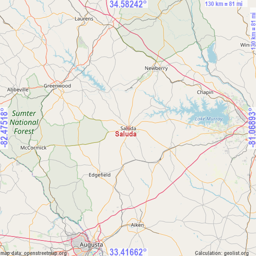
Saluda GPS coordinates[2]
34° 0' 5.472" North, 81° 46' 19.38" West
| Map corner | latitude | longitude |
|---|---|---|
| Upper-left | 34.58242°, | -82.47518° |
| Center: | 34.00152°, | -81.77205° |
| Lower-right: | 33.41662°, | -81.06893° |
| Map W x H: | 129.6×129.6 km | = 80.5×80.5mi |
| max Lat: | 71.29058° ⇑80.2% North |
| Saluda: | 34.00152° |
| min Lat: | ⇓19.8% South 19.06759° |
| min Long | Saluda | max Long |
| -171.73463° | -81.77205° | -66.98998° |
| W 66.4%⇐ | ⇒33.6% E |
Elevation
Elevation of Saluda is 147 m = 482 ft, and this is 147.8 m = 485 ft below average elevation for this country.
| Max E: |
3189 m = 10463 ft | 61.5% |
| Avg. | 294.8 m = 967 ft | |
| Saluda | 147 m = 482 ft | |
Min E: |
-60 m = -197 ft | 38.5% |
See also: United States elevation on elevation.city.
Geographical zone
Saluda is located in North temperate zone (between Tropic of Cancer and the Arctic Circle). Distance of this Northern Tropic circle is 1174.7 km =729.9 mi to South.| Distance of | km | miles | from Saluda |
|---|---|---|---|
| North Pole | 6226.4 | 3868.9 | to North |
| Arctic Circle | 3620.6 | 2249.7 | to North |
| Tropic Cancer | 1174.7 | 729.9 | to South |
| Equator | 3780.6 | 2349.2 | to South |


Nearby cities:
15 places around Saluda: (largest is in red/bold)
• Batesburg
23.2 km =14.4 mi,  116°
116°
• Batesburg-Leesville
23.9 km =14.9 mi, 115°
• Chapin
43 km =26.7 mi,  64°
64°
• Edgefield
27.7 km =17.2 mi,  211°
211°
• Gilbert
35.9 km =22.3 mi,  103°
103°
• Greenwood
41.9 km =26 mi,  300°
300°
• Joanna
46.1 km =28.6 mi,  355°
355°
• Johnston
19 km =11.8 mi,  188°
188°
• Leesville
25.7 km =16 mi,  111°
111°
• Murphys Estates
47.3 km =29.4 mi,  199°
199°
• Newberry
33.5 km =20.8 mi,  24°
24°
• Ninety Six
30.2 km =18.8 mi,  309°
309°
• Promised Land
45.3 km =28.1 mi,  288°
288°
• Prosperity
31.9 km =19.8 mi,  43°
43°
• Ridge Spring
20.1 km =12.5 mi,  149°
149°
Sources, notices
• [Note1] Compared only with cities in United States existing in our database
• [Src1] Map data: © OpenStreetMap contributors (CC-BY-SA)
• [Src2] Other city data from geonames.org with taken over terms of usage.
• [Src3] Geographical zone / Annual Mean Temperature by Robert A. Rohde @ Wikipedia
