Columbia geodata
Columbia (South Carolina) is a seat of a first-order administrative division; located in United States in America/New_York (GMT-4) time zone. With population of 133,803 people, there are 224 cities with bigger population in this country. Compared to other cities in United States, 80.2% of cities are located further ↑North; 69.4% of cities are located further ←West and 70.6% of cities have higher elevation than Columbia. Note1


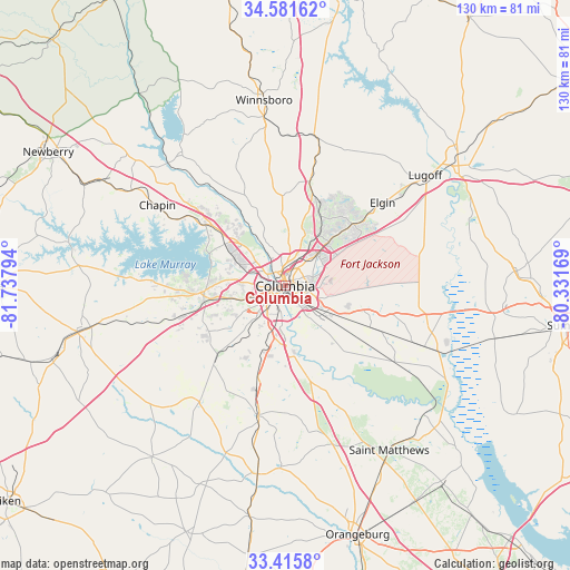
Columbia GPS coordinates[2]
34° 0' 2.556" North, 81° 2' 5.316" West
| Map corner | latitude | longitude |
|---|---|---|
| Upper-left | 34.58162°, | -81.73794° |
| Center: | 34.00071°, | -81.03481° |
| Lower-right: | 33.4158°, | -80.33169° |
| Map W x H: | 129.6×129.6 km | = 80.5×80.5mi |
| max Lat: | 71.29058° ⇑80.2% North |
| Columbia: | 34.00071° |
| min Lat: | ⇓19.8% South 19.06759° |
| min Long | Columbia | max Long |
| -171.73463° | -81.03481° | -66.98998° |
| W 69.4%⇐ | ⇒30.6% E |
Elevation
Elevation of Columbia is 97 m = 318 ft, and this is 197.8 m = 649 ft below average elevation for this country.
| Max E: |
3189 m = 10463 ft | 70.6% |
| Avg. | 294.8 m = 967 ft | |
| Columbia | 97 m = 318 ft | |
Min E: |
-60 m = -197 ft | 29.4% |
See also: Columbia elevation on elevation.city.
Geographical zone
Columbia is located in North temperate zone (between Tropic of Cancer and the Arctic Circle). Distance of this Northern Tropic circle is 1174.6 km =729.9 mi to South.| Distance of | km | miles | from Columbia |
|---|---|---|---|
| North Pole | 6226.5 | 3869 | to North |
| Arctic Circle | 3620.6 | 2249.7 | to North |
| Tropic Cancer | 1174.6 | 729.9 | to South |
| Equator | 3780.5 | 2349.1 | to South |


Nearby cities:
15 places around Columbia: (largest is in red/bold)
• Arcadia Lakes
9 km =5.6 mi,  48°
48°
• Cayce
5.3 km =3.3 mi,  222°
222°
• Dentsville
10 km =6.2 mi, 45°
• Forest Acres
4.6 km =2.9 mi,  63°
63°
• Hopkins
18.1 km =11.2 mi,  126°
126°
• Irmo
16.6 km =10.3 mi,  304°
304°
• Lexington
18.7 km =11.6 mi,  263°
263°
• Oak Grove
10.2 km =6.3 mi, 257°
• Pineridge
11.9 km =7.4 mi,  212°
212°
• Saint Andrews
10 km =6.2 mi, 299°
• Seven Oaks
11.6 km =7.2 mi, 297°
• South Congaree
13.6 km =8.5 mi, 222°
• Springdale
8.2 km =5.1 mi,  236°
236°
• West Columbia
3.7 km =2.3 mi, 257°
• Woodfield
11.6 km =7.2 mi, 55°
Sources, notices
• [Note1] Compared only with cities in United States existing in our database
• [Src1] Map data: © OpenStreetMap contributors (CC-BY-SA)
• [Src2] Other city data from geonames.org with taken over terms of usage.
• [Src3] Geographical zone / Annual Mean Temperature by Robert A. Rohde @ Wikipedia
