Forest Acres geodata
Forest Acres (South Carolina) is a populated place; located in United States in America/New_York (GMT-4) time zone. With population of 10,615 people, there are 4297 cities with bigger population in this country. Compared to other cities in United States, 80.1% of cities are located further ↑North; 69.5% of cities are located further ←West and 74.2% of cities have higher elevation than Forest Acres. Note1


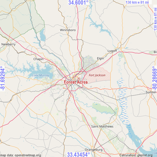
Forest Acres GPS coordinates[2]
34° 1' 9.552" North, 80° 59' 23.316" West
| Map corner | latitude | longitude |
|---|---|---|
| Upper-left | 34.6001°, | -81.69294° |
| Center: | 34.01932°, | -80.98981° |
| Lower-right: | 33.43454°, | -80.28669° |
| Map W x H: | 129.6×129.6 km | = 80.5×80.5mi |
| max Lat: | 71.29058° ⇑80.1% North |
| Forest Acres: | 34.01932° |
| min Lat: | ⇓19.9% South 19.06759° |
| min Long | Forest Acres | max Long |
| -171.73463° | -80.98981° | -66.98998° |
| W 69.5%⇐ | ⇒30.5% E |
Elevation
Elevation of Forest Acres is 76 m = 249 ft, and this is 218.8 m = 718 ft below average elevation for this country.
| Max E: |
3189 m = 10463 ft | 74.2% |
| Avg. | 294.8 m = 967 ft | |
| Forest Acres | 76 m = 249 ft | |
Min E: |
-60 m = -197 ft | 25.8% |
See also: United States elevation on elevation.city.
Geographical zone
Forest Acres is located in North temperate zone (between Tropic of Cancer and the Arctic Circle). Distance of this Northern Tropic circle is 1176.7 km =731.2 mi to South.| Distance of | km | miles | from Forest Acres |
|---|---|---|---|
| North Pole | 6224.5 | 3867.7 | to North |
| Arctic Circle | 3618.6 | 2248.5 | to North |
| Tropic Cancer | 1176.7 | 731.2 | to South |
| Equator | 3782.6 | 2350.4 | to South |


Nearby cities:
15 places around Forest Acres: (largest is in red/bold)
• Arcadia Lakes
4.6 km =2.9 mi,  34°
34°
• Blythewood
21.7 km =13.5 mi,  3°
3°
• Cayce
9.8 km =6.1 mi,  232°
232°
• Columbia
4.6 km =2.9 mi,  243°
243°
• Dentsville
5.8 km =3.6 mi, 30°
• Hopkins
16.5 km =10.3 mi,  140°
140°
• Irmo
19.3 km =12 mi,  292°
292°
• Oak Grove
14.7 km =9.1 mi,  253°
253°
• Pineridge
16.1 km =10 mi,  221°
221°
• Saint Andrews
13.2 km =8.2 mi,  282°
282°
• Seven Oaks
14.8 km =9.2 mi, 282°
• South Congaree
18.1 km =11.2 mi, 228°
• Springdale
12.9 km =8 mi, 238°
• West Columbia
8.3 km =5.2 mi, 249°
• Woodfield
7 km =4.3 mi,  50°
50°
Sources, notices
• [Note1] Compared only with cities in United States existing in our database
• [Src1] Map data: © OpenStreetMap contributors (CC-BY-SA)
• [Src2] Other city data from geonames.org with taken over terms of usage.
• [Src3] Geographical zone / Annual Mean Temperature by Robert A. Rohde @ Wikipedia
