Hopkins geodata
Hopkins (South Carolina) is a populated place; located in United States in America/New_York (GMT-4) time zone. With population of 2,882 people, there are 9847 cities with bigger population in this country. Compared to other cities in United States, 80.9% of cities are located further ↑North; 69.7% of cities are located further ←West and 78.6% of cities have higher elevation than Hopkins. Note1


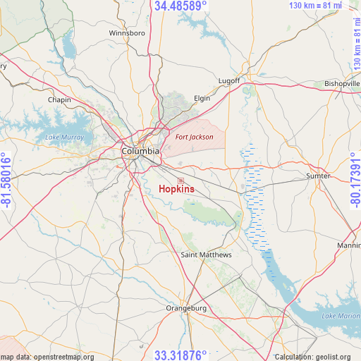
Hopkins GPS coordinates[2]
33° 54' 15.552" North, 80° 52' 37.308" West
| Map corner | latitude | longitude |
|---|---|---|
| Upper-left | 34.48589°, | -81.58016° |
| Center: | 33.90432°, | -80.87703° |
| Lower-right: | 33.31876°, | -80.17391° |
| Map W x H: | 129.8×129.8 km | = 80.7×80.7mi |
| max Lat: | 71.29058° ⇑80.9% North |
| Hopkins: | 33.90432° |
| min Lat: | ⇓19.1% South 19.06759° |
| min Long | Hopkins | max Long |
| -171.73463° | -80.87703° | -66.98998° |
| W 69.7%⇐ | ⇒30.3% E |
Elevation
Elevation of Hopkins is 53 m = 174 ft, and this is 241.8 m = 793 ft below average elevation for this country.
| Max E: |
3189 m = 10463 ft | 78.6% |
| Avg. | 294.8 m = 967 ft | |
| Hopkins | 53 m = 174 ft | |
Min E: |
-60 m = -197 ft | 21.4% |
See also: United States elevation on elevation.city.
Geographical zone
Hopkins is located in North temperate zone (between Tropic of Cancer and the Arctic Circle). Distance of this Northern Tropic circle is 1163.9 km =723.2 mi to South.| Distance of | km | miles | from Hopkins |
|---|---|---|---|
| North Pole | 6237.3 | 3875.7 | to North |
| Arctic Circle | 3631.4 | 2256.4 | to North |
| Tropic Cancer | 1163.9 | 723.2 | to South |
| Equator | 3769.8 | 2342.4 | to South |


Nearby cities:
15 places around Hopkins: (largest is in red/bold)
• Arcadia Lakes
18.3 km =11.4 mi,  334°
334°
• Cayce
19.4 km =12.1 mi,  290°
290°
• Columbia
18.1 km =11.2 mi,  306°
306°
• Dentsville
19.3 km =12 mi,  337°
337°
• Eastover
17.3 km =10.7 mi,  100°
100°
• Forest Acres
16.5 km =10.3 mi,  320°
320°
• Gadsden
12.2 km =7.6 mi,  122°
122°
• Gaston
22.8 km =14.2 mi,  244°
244°
• Oak Grove
16.3 km =10.1 mi,  210°
210°
• Oak Grove
26 km =16.2 mi, 289°
• Pineridge
21 km =13 mi,  271°
271°
• South Congaree
23.9 km =14.9 mi, 271°
• Springdale
22.3 km =13.9 mi, 285°
• West Columbia
20.7 km =12.9 mi,  298°
298°
• Woodfield
17.9 km =11.1 mi, 343°
Sources, notices
• [Note1] Compared only with cities in United States existing in our database
• [Src1] Map data: © OpenStreetMap contributors (CC-BY-SA)
• [Src2] Other city data from geonames.org with taken over terms of usage.
• [Src3] Geographical zone / Annual Mean Temperature by Robert A. Rohde @ Wikipedia
