Florence geodata
Florence (South Carolina) is a seat of a second-order administrative division; located in United States in America/New_York (GMT-4) time zone. With population of 38,228 people, there are 1266 cities with bigger population in this country. Compared to other cities in United States, 79% of cities are located further ↑North; 74.3% of cities are located further ←West and 80.3% of cities have higher elevation than Florence. Note1


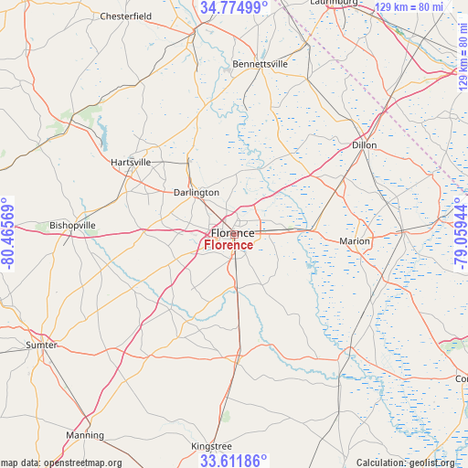
Florence GPS coordinates[2]
34° 11' 43.548" North, 79° 45' 45.216" West
| Map corner | latitude | longitude |
|---|---|---|
| Upper-left | 34.77499°, | -80.46569° |
| Center: | 34.19543°, | -79.76256° |
| Lower-right: | 33.61186°, | -79.05944° |
| Map W x H: | 129.3×129.3 km | = 80.3×80.3mi |
| max Lat: | 71.29058° ⇑79% North |
| Florence: | 34.19543° |
| min Lat: | ⇓21% South 19.06759° |
| min Long | Florence | max Long |
| -171.73463° | -79.76256° | -66.98998° |
| W 74.3%⇐ | ⇒25.7% E |
Elevation
Elevation of Florence is 45 m = 148 ft, and this is 249.8 m = 820 ft below average elevation for this country.
| Max E: |
3189 m = 10463 ft | 80.3% |
| Avg. | 294.8 m = 967 ft | |
| Florence | 45 m = 148 ft | |
Min E: |
-60 m = -197 ft | 19.7% |
See also: United States elevation on elevation.city.
Geographical zone
Florence is located in North temperate zone (between Tropic of Cancer and the Arctic Circle). Distance of this Northern Tropic circle is 1196.3 km =743.3 mi to South.| Distance of | km | miles | from Florence |
|---|---|---|---|
| North Pole | 6204.9 | 3855.5 | to North |
| Arctic Circle | 3599 | 2236.3 | to North |
| Tropic Cancer | 1196.3 | 743.3 | to South |
| Equator | 3802.2 | 2362.6 | to South |


Nearby cities:
15 places around Florence: (largest is in red/bold)
• Coward
24.7 km =15.3 mi,  176°
176°
• Darlington
15.6 km =9.7 mi,  318°
318°
• Hartsville
34.8 km =21.6 mi,  304°
304°
• Lake City
36.1 km =22.4 mi, 178°
• Lamar
27.8 km =17.3 mi,  263°
263°
• Latta
34.3 km =21.3 mi,  62°
62°
• Lydia
33.8 km =21 mi,  287°
287°
• Marion
33.3 km =20.7 mi,  93°
93°
• North Hartsville
35.8 km =22.2 mi,  308°
308°
• Olanta
32.9 km =20.4 mi,  208°
208°
• Pamplico
28.4 km =17.6 mi,  141°
141°
• Quinby
5.2 km =3.2 mi,  29°
29°
• Scranton
30.9 km =19.2 mi, 176°
• Society Hill
36.2 km =22.5 mi,  347°
347°
• Timmonsville
17.6 km =10.9 mi,  247°
247°
Sources, notices
• [Note1] Compared only with cities in United States existing in our database
• [Src1] Map data: © OpenStreetMap contributors (CC-BY-SA)
• [Src2] Other city data from geonames.org with taken over terms of usage.
• [Src3] Geographical zone / Annual Mean Temperature by Robert A. Rohde @ Wikipedia
