Lake City geodata
Lake City (South Carolina) is a populated place; located in United States in America/New_York (GMT-4) time zone. With population of 6,788 people, there are 5928 cities with bigger population in this country. Compared to other cities in United States, 81.1% of cities are located further ↑North; 74.3% of cities are located further ←West and 87.4% of cities have higher elevation than Lake City. Note1


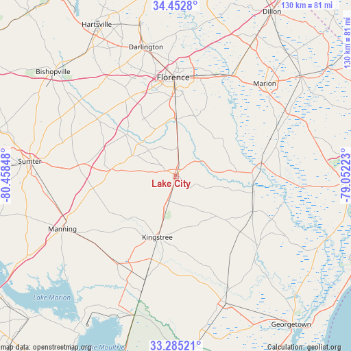
Lake City GPS coordinates[2]
33° 52' 15.6" North, 79° 45' 19.26" West
| Map corner | latitude | longitude |
|---|---|---|
| Upper-left | 34.4528°, | -80.45848° |
| Center: | 33.871°, | -79.75535° |
| Lower-right: | 33.28521°, | -79.05223° |
| Map W x H: | 129.8×129.8 km | = 80.7×80.7mi |
| max Lat: | 71.29058° ⇑81.1% North |
| Lake City: | 33.871° |
| min Lat: | ⇓18.9% South 19.06759° |
| min Long | Lake City | max Long |
| -171.73463° | -79.75535° | -66.98998° |
| W 74.3%⇐ | ⇒25.7% E |
Elevation
Elevation of Lake City is 22 m = 72 ft, and this is 272.8 m = 895 ft below average elevation for this country.
| Max E: |
3189 m = 10463 ft | 87.4% |
| Avg. | 294.8 m = 967 ft | |
| Lake City | 22 m = 72 ft | |
Min E: |
-60 m = -197 ft | 12.6% |
See also: United States elevation on elevation.city.
Geographical zone
Lake City is located in North temperate zone (between Tropic of Cancer and the Arctic Circle). Distance of this Northern Tropic circle is 1160.2 km =720.9 mi to South.| Distance of | km | miles | from Lake City |
|---|---|---|---|
| North Pole | 6241 | 3878 | to North |
| Arctic Circle | 3635.1 | 2258.7 | to North |
| Tropic Cancer | 1160.2 | 720.9 | to South |
| Equator | 3766.1 | 2340.1 | to South |


Nearby cities:
15 places around Lake City: (largest is in red/bold)
• Coward
11.4 km =7.1 mi,  3°
3°
• Florence
36.1 km =22.4 mi,  358°
358°
• Johnsonville
28.9 km =18 mi,  101°
101°
• Kingstree
23.7 km =14.7 mi,  197°
197°
• Lamar
43.6 km =27.1 mi,  319°
319°
• Manning
46.4 km =28.8 mi,  245°
245°
• Marion
47.3 km =29.4 mi,  43°
43°
• Mayesville
43.7 km =27.2 mi,  287°
287°
• Olanta
17.9 km =11.1 mi, 293°
• Pamplico
22 km =13.7 mi,  50°
50°
• Quinby
40.7 km =25.3 mi, 2°
• Red Hill
48 km =29.8 mi,  72°
72°
• Scranton
5.3 km =3.3 mi,  11°
11°
• Timmonsville
33.9 km =21.1 mi,  329°
329°
• Turbeville
24.4 km =15.2 mi,  275°
275°
Sources, notices
• [Note1] Compared only with cities in United States existing in our database
• [Src1] Map data: © OpenStreetMap contributors (CC-BY-SA)
• [Src2] Other city data from geonames.org with taken over terms of usage.
• [Src3] Geographical zone / Annual Mean Temperature by Robert A. Rohde @ Wikipedia
