North Hartsville geodata
North Hartsville (South Carolina) is a populated place; located in United States in America/New_York (GMT-4) time zone. With population of 3,251 people, there are 9229 cities with bigger population in this country. Compared to other cities in United States, 78.1% of cities are located further ↑North; 73% of cities are located further ←West and 76.5% of cities have higher elevation than North Hartsville. Note1


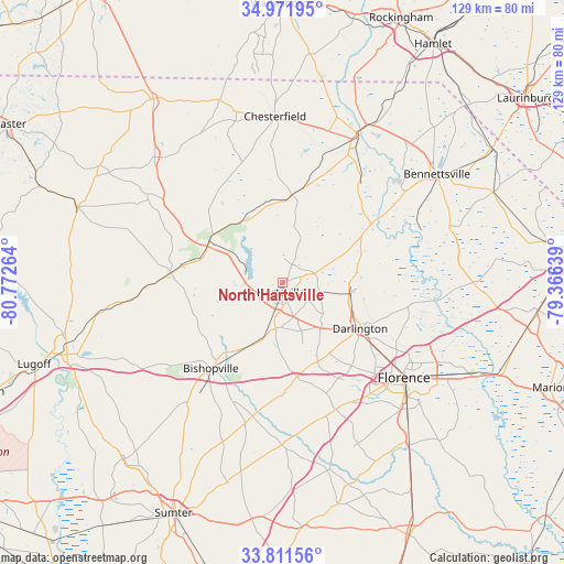
North Hartsville GPS coordinates[2]
34° 23' 37.572" North, 80° 4' 10.236" West
| Map corner | latitude | longitude |
|---|---|---|
| Upper-left | 34.97195°, | -80.77264° |
| Center: | 34.39377°, | -80.06951° |
| Lower-right: | 33.81156°, | -79.36639° |
| Map W x H: | 129×129 km | = 80.2×80.2mi |
| max Lat: | 71.29058° ⇑78.1% North |
| North Hartsville: | 34.39377° |
| min Lat: | ⇓21.9% South 19.06759° |
| min Long | North Hartsvill | max Long |
| -171.73463° | -80.06951° | -66.98998° |
| W 73%⇐ | ⇒27% E |
Elevation
Elevation of North Hartsville is 63 m = 207 ft, and this is 231.8 m = 760 ft below average elevation for this country.
| Max E: |
3189 m = 10463 ft | 76.5% |
| Avg. | 294.8 m = 967 ft | |
| North Hartsville | 63 m = 207 ft | |
Min E: |
-60 m = -197 ft | 23.5% |
See also: United States elevation on elevation.city.
Geographical zone
North Hartsville is located in North temperate zone (between Tropic of Cancer and the Arctic Circle). Distance of this Northern Tropic circle is 1218.3 km =757 mi to South.| Distance of | km | miles | from North Hartsville |
|---|---|---|---|
| North Pole | 6182.8 | 3841.8 | to North |
| Arctic Circle | 3576.9 | 2222.6 | to North |
| Tropic Cancer | 1218.3 | 757 | to South |
| Equator | 3824.2 | 2376.2 | to South |


Nearby cities:
15 places around North Hartsville: (largest is in red/bold)
• Bennettsville
43.1 km =26.8 mi,  54°
54°
• Bishopville
25.5 km =15.8 mi,  220°
220°
• Cheraw
37.8 km =23.5 mi,  26°
26°
• Chesterfield
38.1 km =23.7 mi,  357°
357°
• Darlington
20.6 km =12.8 mi,  120°
120°
• Florence
35.8 km =22.2 mi,  128°
128°
• Hartsville
2.2 km =1.4 mi,  189°
189°
• Jefferson
40.9 km =25.4 mi,  314°
314°
• Lamar
25 km =15.5 mi,  178°
178°
• Lydia
12.3 km =7.6 mi,  198°
198°
• McBee
19 km =11.8 mi,  296°
296°
• Quinby
35.4 km =22 mi, 119°
• Society Hill
24 km =14.9 mi,  56°
56°
• Timmonsville
31.2 km =19.4 mi,  157°
157°
• Wallace
41.9 km =26 mi, 29°
Sources, notices
• [Note1] Compared only with cities in United States existing in our database
• [Src1] Map data: © OpenStreetMap contributors (CC-BY-SA)
• [Src2] Other city data from geonames.org with taken over terms of usage.
• [Src3] Geographical zone / Annual Mean Temperature by Robert A. Rohde @ Wikipedia
