Fountain Inn geodata
Fountain Inn (South Carolina) is a populated place; located in United States in America/New_York (GMT-4) time zone. With population of 8,317 people, there are 5125 cities with bigger population in this country. Compared to other cities in United States, 76.9% of cities are located further ↑North; 64.9% of cities are located further ←West and 65.8% of cities have lower elevation than Fountain Inn. Note1


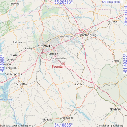
Fountain Inn GPS coordinates[2]
34° 41' 20.436" North, 82° 11' 44.412" West
| Map corner | latitude | longitude |
|---|---|---|
| Upper-left | 35.26513°, | -82.8988° |
| Center: | 34.68901°, | -82.19567° |
| Lower-right: | 34.10885°, | -81.49255° |
| Map W x H: | 128.6×128.6 km | = 79.9×79.9mi |
| max Lat: | 71.29058° ⇑76.9% North |
| Fountain Inn: | 34.68901° |
| min Lat: | ⇓23.1% South 19.06759° |
| min Long | Fountain Inn | max Long |
| -171.73463° | -82.19567° | -66.98998° |
| W 64.9%⇐ | ⇒35.1% E |
Elevation
Elevation of Fountain Inn is 266 m = 873 ft, and this is 28.8 m = 94 ft below average elevation for this country.
| Max E: |
3189 m = 10463 ft | 34.2% |
| Avg. | 294.8 m = 967 ft | |
| Fountain Inn | 266 m = 873 ft | |
Min E: |
-60 m = -197 ft | 65.8% |
See also: United States elevation on elevation.city.
Geographical zone
Fountain Inn is located in North temperate zone (between Tropic of Cancer and the Arctic Circle). Distance of this Northern Tropic circle is 1251.1 km =777.4 mi to South.| Distance of | km | miles | from Fountain Inn |
|---|---|---|---|
| North Pole | 6150 | 3821.4 | to North |
| Arctic Circle | 3544.1 | 2202.2 | to North |
| Tropic Cancer | 1251.1 | 777.4 | to South |
| Equator | 3857.1 | 2396.7 | to South |


Nearby cities:
15 places around Fountain Inn: (largest is in red/bold)
• Dunean
25.4 km =15.8 mi,  306°
306°
• Enoree
21.4 km =13.3 mi,  99°
99°
• Five Forks
13.2 km =8.2 mi,  346°
346°
• Gantt
24.3 km =15.1 mi,  300°
300°
• Golden Grove
23.2 km =14.4 mi,  282°
282°
• Gray Court
11.7 km =7.3 mi,  140°
140°
• Greenville
25.7 km =16 mi,  315°
315°
• Judson
26.6 km =16.5 mi, 307°
• Laurens
26.9 km =16.7 mi, 141°
• Mauldin
14.5 km =9 mi, 313°
• Piedmont
24.6 km =15.3 mi,  273°
273°
• Reidville
20.7 km =12.9 mi,  21°
21°
• Simpsonville
7.6 km =4.7 mi, 314°
• West Pelzer
25.6 km =15.9 mi,  258°
258°
• Woodruff
15.5 km =9.6 mi,  68°
68°
Sources, notices
• [Note1] Compared only with cities in United States existing in our database
• [Src1] Map data: © OpenStreetMap contributors (CC-BY-SA)
• [Src2] Other city data from geonames.org with taken over terms of usage.
• [Src3] Geographical zone / Annual Mean Temperature by Robert A. Rohde @ Wikipedia
