Laurens geodata
Laurens (South Carolina) is a seat of a second-order administrative division; located in United States in America/New_York (GMT-4) time zone. With population of 9,166 people, there are 4747 cities with bigger population in this country. Compared to other cities in United States, 77.7% of cities are located further ↑North; 65.5% of cities are located further ←West and 52.2% of cities have higher elevation than Laurens. Note1


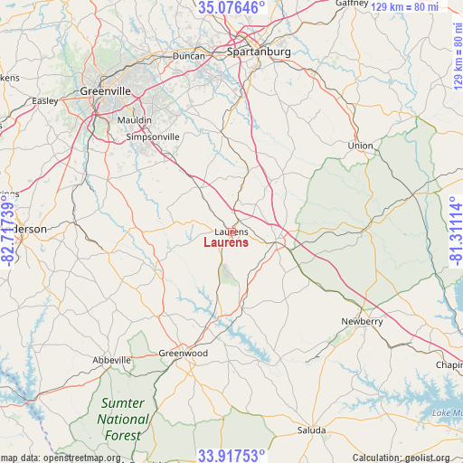
Laurens GPS coordinates[2]
34° 29' 56.436" North, 82° 0' 51.336" West
| Map corner | latitude | longitude |
|---|---|---|
| Upper-left | 35.07646°, | -82.71739° |
| Center: | 34.49901°, | -82.01426° |
| Lower-right: | 33.91753°, | -81.31114° |
| Map W x H: | 128.9×128.9 km | = 80.1×80.1mi |
| max Lat: | 71.29058° ⇑77.7% North |
| Laurens: | 34.49901° |
| min Lat: | ⇓22.3% South 19.06759° |
| min Long | Laurens | max Long |
| -171.73463° | -82.01426° | -66.98998° |
| W 65.5%⇐ | ⇒34.5% E |
Elevation
Elevation of Laurens is 190 m = 623 ft, and this is 104.8 m = 344 ft below average elevation for this country.
| Max E: |
3189 m = 10463 ft | 52.2% |
| Avg. | 294.8 m = 967 ft | |
| Laurens | 190 m = 623 ft | |
Min E: |
-60 m = -197 ft | 47.8% |
See also: United States elevation on elevation.city.
Geographical zone
Laurens is located in North temperate zone (between Tropic of Cancer and the Arctic Circle). Distance of this Northern Tropic circle is 1230 km =764.3 mi to South.| Distance of | km | miles | from Laurens |
|---|---|---|---|
| North Pole | 6171.1 | 3834.5 | to North |
| Arctic Circle | 3565.2 | 2215.3 | to North |
| Tropic Cancer | 1230 | 764.3 | to South |
| Equator | 3835.9 | 2383.5 | to South |


Nearby cities:
15 places around Laurens: (largest is in red/bold)
• Clinton
12.6 km =7.8 mi,  103°
103°
• Due West
38.9 km =24.2 mi,  241°
241°
• Enoree
18.1 km =11.2 mi,  14°
14°
• Five Forks
39.3 km =24.4 mi,  329°
329°
• Fountain Inn
26.9 km =16.7 mi,  321°
321°
• Gray Court
15.2 km =9.4 mi, 323°
• Greenwood
36.4 km =22.6 mi,  201°
201°
• Honea Path
35.1 km =21.8 mi,  260°
260°
• Joanna
20.7 km =12.9 mi,  116°
116°
• Ninety Six
36 km =22.4 mi,  181°
181°
• Simpsonville
34.4 km =21.4 mi, 320°
• Ware Shoals
24.1 km =15 mi, 242°
• Watts Mills
3.2 km =2 mi,  53°
53°
• Whitmire
36.9 km =22.9 mi,  89°
89°
• Woodruff
26.8 km =16.7 mi,  355°
355°
Sources, notices
• [Note1] Compared only with cities in United States existing in our database
• [Src1] Map data: © OpenStreetMap contributors (CC-BY-SA)
• [Src2] Other city data from geonames.org with taken over terms of usage.
• [Src3] Geographical zone / Annual Mean Temperature by Robert A. Rohde @ Wikipedia
