Ninety Six geodata
Ninety Six (South Carolina) is a populated place; located in United States in America/New_York (GMT-4) time zone. With population of 2,048 people, there are 11802 cities with bigger population in this country. Compared to other cities in United States, 79.1% of cities are located further ↑North; 65.4% of cities are located further ←West and 57.7% of cities have higher elevation than Ninety Six. Note1


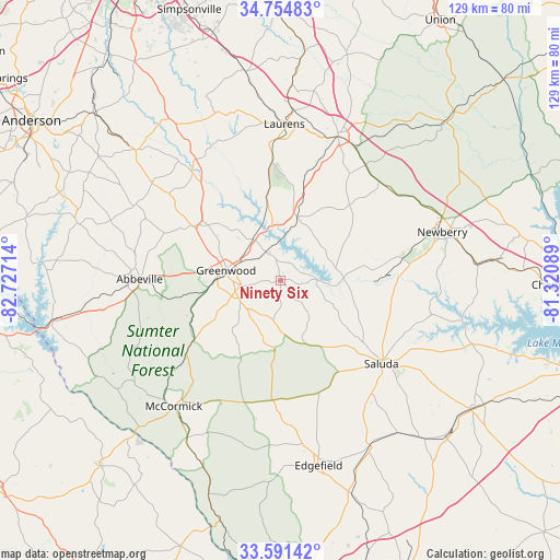
Ninety Six GPS coordinates[2]
34° 10' 30.468" North, 82° 1' 26.436" West
| Map corner | latitude | longitude |
|---|---|---|
| Upper-left | 34.75483°, | -82.72714° |
| Center: | 34.17513°, | -82.02401° |
| Lower-right: | 33.59142°, | -81.32089° |
| Map W x H: | 129.4×129.4 km | = 80.4×80.4mi |
| max Lat: | 71.29058° ⇑79.1% North |
| Ninety Six: | 34.17513° |
| min Lat: | ⇓20.9% South 19.06759° |
| min Long | Ninety Six | max Long |
| -171.73463° | -82.02401° | -66.98998° |
| W 65.4%⇐ | ⇒34.6% E |
Elevation
Elevation of Ninety Six is 167 m = 548 ft, and this is 127.8 m = 419 ft below average elevation for this country.
| Max E: |
3189 m = 10463 ft | 57.7% |
| Avg. | 294.8 m = 967 ft | |
| Ninety Six | 167 m = 548 ft | |
Min E: |
-60 m = -197 ft | 42.3% |
See also: United States elevation on elevation.city.
Geographical zone
Ninety Six is located in North temperate zone (between Tropic of Cancer and the Arctic Circle). Distance of this Northern Tropic circle is 1194 km =741.9 mi to South.| Distance of | km | miles | from Ninety Six |
|---|---|---|---|
| North Pole | 6207.1 | 3856.9 | to North |
| Arctic Circle | 3601.3 | 2237.7 | to North |
| Tropic Cancer | 1194 | 741.9 | to South |
| Equator | 3799.9 | 2361.1 | to South |


Nearby cities:
15 places around Ninety Six: (largest is in red/bold)
• Abbeville
32.7 km =20.3 mi,  270°
270°
• Clinton
35.6 km =22.1 mi,  21°
21°
• Due West
37.8 km =23.5 mi,  297°
297°
• Edgefield
43.7 km =27.2 mi,  168°
168°
• Greenwood
12.9 km =8 mi,  280°
280°
• Joanna
33 km =20.5 mi,  36°
36°
• Johnston
43.3 km =26.9 mi,  151°
151°
• Laurens
36 km =22.4 mi,  1°
1°
• McCormick
38.2 km =23.7 mi,  220°
220°
• Newberry
38.9 km =24.2 mi,  73°
73°
• Promised Land
20.5 km =12.7 mi,  255°
255°
• Prosperity
45.3 km =28.1 mi,  85°
85°
• Saluda
30.2 km =18.8 mi,  129°
129°
• Ware Shoals
32.2 km =20 mi,  320°
320°
• Watts Mills
38.1 km =23.7 mi,  5°
5°
Sources, notices
• [Note1] Compared only with cities in United States existing in our database
• [Src1] Map data: © OpenStreetMap contributors (CC-BY-SA)
• [Src2] Other city data from geonames.org with taken over terms of usage.
• [Src3] Geographical zone / Annual Mean Temperature by Robert A. Rohde @ Wikipedia
