Springfield geodata
Springfield (South Carolina) is a populated place; located in United States in America/New_York (GMT-4) time zone. With population of 503 people, there are 20865 cities with bigger population in this country. Compared to other cities in United States, 83.1% of cities are located further ↑North; 68.6% of cities are located further ←West and 71.5% of cities have higher elevation than Springfield. Note1


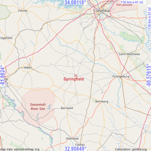
Springfield GPS coordinates[2]
33° 29' 48.552" North, 81° 16' 45.372" West
| Map corner | latitude | longitude |
|---|---|---|
| Upper-left | 34.08118°, | -81.9824° |
| Center: | 33.49682°, | -81.27927° |
| Lower-right: | 32.90849°, | -80.57615° |
| Map W x H: | 130.4×130.4 km | = 81×81mi |
| max Lat: | 71.29058° ⇑83.1% North |
| Springfield: | 33.49682° |
| min Lat: | ⇓16.9% South 19.06759° |
| min Long | Springfield | max Long |
| -171.73463° | -81.27927° | -66.98998° |
| W 68.6%⇐ | ⇒31.4% E |
Elevation
Elevation of Springfield is 92 m = 302 ft, and this is 202.8 m = 665 ft below average elevation for this country.
| Max E: |
3189 m = 10463 ft | 71.5% |
| Avg. | 294.8 m = 967 ft | |
| Springfield | 92 m = 302 ft | |
Min E: |
-60 m = -197 ft | 28.5% |
See also: United States elevation on elevation.city.
Geographical zone
Springfield is located in North temperate zone (between Tropic of Cancer and the Arctic Circle). Distance of this Northern Tropic circle is 1118.6 km =695.1 mi to South.| Distance of | km | miles | from Springfield |
|---|---|---|---|
| North Pole | 6282.6 | 3903.8 | to North |
| Arctic Circle | 3676.7 | 2284.6 | to North |
| Tropic Cancer | 1118.6 | 695.1 | to South |
| Equator | 3724.5 | 2314.3 | to South |


Nearby cities:
15 places around Springfield: (largest is in red/bold)
• Aiken
41.4 km =25.7 mi,  279°
279°
• Bamberg
31.8 km =19.8 mi,  134°
134°
• Barnwell
29 km =18 mi,  194°
194°
• Blackville
15.5 km =9.6 mi,  177°
177°
• Denmark
23.2 km =14.4 mi,  146°
146°
• Edisto
35.4 km =22 mi,  93°
93°
• Gaston
39.3 km =24.4 mi,  24°
24°
• New Ellenton
38.6 km =24 mi,  257°
257°
• North
21.1 km =13.1 mi,  51°
51°
• Orangeburg
39.3 km =24.4 mi, 90°
• Pelion
29.8 km =18.5 mi,  6°
6°
• Swansea
31.7 km =19.7 mi,  32°
32°
• Wagener
18.9 km =11.7 mi,  336°
336°
• Wilkinson Heights
41.4 km =25.7 mi, 89°
• Williston
16.7 km =10.4 mi,  231°
231°
Sources, notices
• [Note1] Compared only with cities in United States existing in our database
• [Src1] Map data: © OpenStreetMap contributors (CC-BY-SA)
• [Src2] Other city data from geonames.org with taken over terms of usage.
• [Src3] Geographical zone / Annual Mean Temperature by Robert A. Rohde @ Wikipedia
