Aiken geodata
Aiken (South Carolina) is a seat of a second-order administrative division; located in United States in America/New_York (GMT-4) time zone. With population of 30,604 people, there are 1626 cities with bigger population in this country. Compared to other cities in United States, 82.8% of cities are located further ↑North; 66.6% of cities are located further ←West and 58.8% of cities have higher elevation than Aiken. Note1


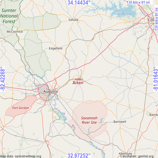
Aiken GPS coordinates[2]
33° 33' 37.512" North, 81° 43' 10.38" West
| Map corner | latitude | longitude |
|---|---|---|
| Upper-left | 34.14434°, | -82.42268° |
| Center: | 33.56042°, | -81.71955° |
| Lower-right: | 32.97252°, | -81.01643° |
| Map W x H: | 130.3×130.3 km | = 81×81mi |
| max Lat: | 71.29058° ⇑82.8% North |
| Aiken: | 33.56042° |
| min Lat: | ⇓17.2% South 19.06759° |
| min Long | Aiken | max Long |
| -171.73463° | -81.71955° | -66.98998° |
| W 66.6%⇐ | ⇒33.4% E |
Elevation
Elevation of Aiken is 161 m = 528 ft, and this is 133.8 m = 439 ft below average elevation for this country.
| Max E: |
3189 m = 10463 ft | 58.8% |
| Avg. | 294.8 m = 967 ft | |
| Aiken | 161 m = 528 ft | |
Min E: |
-60 m = -197 ft | 41.2% |
See also: United States elevation on elevation.city.
Geographical zone
Aiken is located in North temperate zone (between Tropic of Cancer and the Arctic Circle). Distance of this Northern Tropic circle is 1125.6 km =699.4 mi to South.| Distance of | km | miles | from Aiken |
|---|---|---|---|
| North Pole | 6275.5 | 3899.4 | to North |
| Arctic Circle | 3669.6 | 2280.2 | to North |
| Tropic Cancer | 1125.6 | 699.4 | to South |
| Equator | 3731.6 | 2318.7 | to South |


Nearby cities:
15 places around Aiken: (largest is in red/bold)
• Augusta
25.7 km =16 mi,  247°
247°
• Belvedere
21.1 km =13.1 mi,  261°
261°
• Burnettown
13 km =8.1 mi, 247°
• Clearwater
17.5 km =10.9 mi, 246°
• Edgefield
32 km =19.9 mi,  322°
322°
• Gloverville
10.9 km =6.8 mi, 249°
• Graniteville
8.2 km =5.1 mi,  272°
272°
• Jackson
26.9 km =16.7 mi,  193°
193°
• Johnston
31.1 km =19.3 mi,  346°
346°
• Langley
12.5 km =7.8 mi, 247°
• Murphys Estates
21.3 km =13.2 mi,  282°
282°
• New Ellenton
15.8 km =9.8 mi,  168°
168°
• North Augusta
23.7 km =14.7 mi, 254°
• Ridge Spring
32.1 km =19.9 mi,  9°
9°
• Warrenville
7.9 km =4.9 mi, 262°
Sources, notices
• [Note1] Compared only with cities in United States existing in our database
• [Src1] Map data: © OpenStreetMap contributors (CC-BY-SA)
• [Src2] Other city data from geonames.org with taken over terms of usage.
• [Src3] Geographical zone / Annual Mean Temperature by Robert A. Rohde @ Wikipedia
