Gaston geodata
Gaston (South Carolina) is a populated place; located in United States in America/New_York (GMT-4) time zone. With population of 1,658 people, there are 13056 cities with bigger population in this country. Compared to other cities in United States, 81.4% of cities are located further ↑North; 69.2% of cities are located further ←West and 60.7% of cities have higher elevation than Gaston. Note1


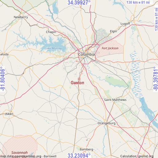
Gaston GPS coordinates[2]
33° 49' 1.56" North, 81° 6' 3.348" West
| Map corner | latitude | longitude |
|---|---|---|
| Upper-left | 34.39927°, | -81.80406° |
| Center: | 33.8171°, | -81.10093° |
| Lower-right: | 33.23094°, | -80.39781° |
| Map W x H: | 129.9×129.9 km | = 80.7×80.7mi |
| max Lat: | 71.29058° ⇑81.4% North |
| Gaston: | 33.8171° |
| min Lat: | ⇓18.6% South 19.06759° |
| min Long | Gaston | max Long |
| -171.73463° | -81.10093° | -66.98998° |
| W 69.2%⇐ | ⇒30.8% E |
Elevation
Elevation of Gaston is 151 m = 495 ft, and this is 143.8 m = 472 ft below average elevation for this country.
| Max E: |
3189 m = 10463 ft | 60.7% |
| Avg. | 294.8 m = 967 ft | |
| Gaston | 151 m = 495 ft | |
Min E: |
-60 m = -197 ft | 39.3% |
See also: United States elevation on elevation.city.
Geographical zone
Gaston is located in North temperate zone (between Tropic of Cancer and the Arctic Circle). Distance of this Northern Tropic circle is 1154.2 km =717.2 mi to South.| Distance of | km | miles | from Gaston |
|---|---|---|---|
| North Pole | 6247 | 3881.7 | to North |
| Arctic Circle | 3641.1 | 2262.5 | to North |
| Tropic Cancer | 1154.2 | 717.2 | to South |
| Equator | 3760.1 | 2336.4 | to South |


Nearby cities:
15 places around Gaston: (largest is in red/bold)
• Cayce
16.7 km =10.4 mi,  8°
8°
• Columbia
21.3 km =13.2 mi,  16°
16°
• Forest Acres
24.7 km =15.3 mi, 24°
• Hopkins
22.8 km =14.2 mi,  64°
64°
• Lexington
22.1 km =13.7 mi,  325°
325°
• North
22.4 km =13.9 mi,  180°
180°
• Oak Grove
13.1 km =8.1 mi,  109°
109°
• Oak Grove
18.6 km =11.6 mi,  348°
348°
• Pelion
14.6 km =9.1 mi,  245°
245°
• Pineridge
10.4 km =6.5 mi,  358°
358°
• Red Bank
18 km =11.2 mi,  315°
315°
• South Congaree
10.9 km =6.8 mi,  342°
342°
• Springdale
15.8 km =9.8 mi, 357°
• Swansea
8.8 km =5.5 mi, 178°
• West Columbia
19.8 km =12.3 mi, 7°
Sources, notices
• [Note1] Compared only with cities in United States existing in our database
• [Src1] Map data: © OpenStreetMap contributors (CC-BY-SA)
• [Src2] Other city data from geonames.org with taken over terms of usage.
• [Src3] Geographical zone / Annual Mean Temperature by Robert A. Rohde @ Wikipedia
