Ashland City geodata
Ashland City (Tennessee) is a seat of a second-order administrative division; located in United States in America/Chicago (GMT-5) time zone. With population of 4,649 people, there are 7489 cities with bigger population in this country. Compared to other cities in United States, 69% of cities are located further ↑North; 50.1% of cities are located further ←West and 64.2% of cities have higher elevation than Ashland City. Note1


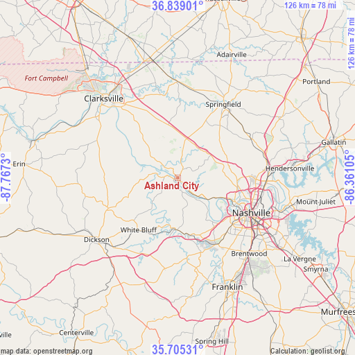
Ashland City GPS coordinates[2]
36° 16' 27.192" North, 87° 3' 51.012" West
| Map corner | latitude | longitude |
|---|---|---|
| Upper-left | 36.83901°, | -87.7673° |
| Center: | 36.27422°, | -87.06417° |
| Lower-right: | 35.70531°, | -86.36105° |
| Map W x H: | 126.1×126.1 km | = 78.4×78.4mi |
| max Lat: | 71.29058° ⇑69% North |
| Ashland City: | 36.27422° |
| min Lat: | ⇓31% South 19.06759° |
| min Long | Ashland City | max Long |
| -171.73463° | -87.06417° | -66.98998° |
| W 50.1%⇐ | ⇒49.9% E |
Elevation
Elevation of Ashland City is 132 m = 433 ft, and this is 162.8 m = 534 ft below average elevation for this country.
| Max E: |
3189 m = 10463 ft | 64.2% |
| Avg. | 294.8 m = 967 ft | |
| Ashland City | 132 m = 433 ft | |
Min E: |
-60 m = -197 ft | 35.8% |
See also: United States elevation on elevation.city.
Geographical zone
Ashland City is located in North temperate zone (between Tropic of Cancer and the Arctic Circle). Distance of this Northern Tropic circle is 1427.4 km =886.9 mi to South.| Distance of | km | miles | from Ashland City |
|---|---|---|---|
| North Pole | 5973.7 | 3711.9 | to North |
| Arctic Circle | 3367.9 | 2092.7 | to North |
| Tropic Cancer | 1427.4 | 886.9 | to South |
| Equator | 4033.3 | 2506.2 | to South |


Nearby cities:
15 places around Ashland City: (largest is in red/bold)
• Belle Meade
27.2 km =16.9 mi,  136°
136°
• Berry Hill
31.9 km =19.8 mi,  123°
123°
• Charlotte
27 km =16.8 mi,  246°
246°
• Coopertown
20.1 km =12.5 mi,  25°
25°
• Forest Hills
30.2 km =18.8 mi, 139°
• Goodlettsville
31.9 km =19.8 mi,  80°
80°
• Greenbrier
28.8 km =17.9 mi,  53°
53°
• Kingston Springs
19.7 km =12.2 mi,  193°
193°
• Nashville
27.8 km =17.3 mi, 115°
• Oak Hill
32.6 km =20.3 mi,  129°
129°
• Pegram
19.3 km =12 mi,  176°
176°
• Pleasant View
13.6 km =8.5 mi,  10°
10°
• Ridgetop
28.8 km =17.9 mi,  62°
62°
• Springfield
30.7 km =19.1 mi, 31°
• White Bluff
23.3 km =14.5 mi,  217°
217°
Sources, notices
• [Note1] Compared only with cities in United States existing in our database
• [Src1] Map data: © OpenStreetMap contributors (CC-BY-SA)
• [Src2] Other city data from geonames.org with taken over terms of usage.
• [Src3] Geographical zone / Annual Mean Temperature by Robert A. Rohde @ Wikipedia
