Berry Hill geodata
Berry Hill (Tennessee) is a populated place; located in United States in America/Chicago (GMT-5) time zone. With population of 547 people, there are 20307 cities with bigger population in this country. Compared to other cities in United States, 69.8% of cities are located further ↑North; 50.9% of cities are located further ←West and 57.7% of cities have higher elevation than Berry Hill. Note1


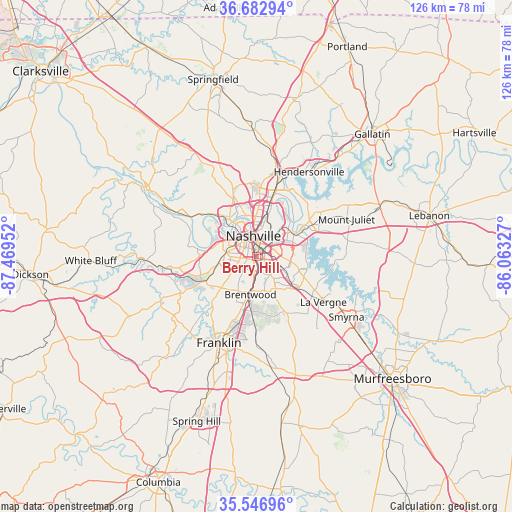
Berry Hill GPS coordinates[2]
36° 7' 1.2" North, 86° 45' 59.004" West
| Map corner | latitude | longitude |
|---|---|---|
| Upper-left | 36.68294°, | -87.46952° |
| Center: | 36.117°, | -86.76639° |
| Lower-right: | 35.54696°, | -86.06327° |
| Map W x H: | 126.3×126.3 km | = 78.5×78.5mi |
| max Lat: | 71.29058° ⇑69.8% North |
| Berry Hill: | 36.117° |
| min Lat: | ⇓30.2% South 19.06759° |
| min Long | Berry Hill | max Long |
| -171.73463° | -86.76639° | -66.98998° |
| W 50.9%⇐ | ⇒49.1% E |
Elevation
Elevation of Berry Hill is 167 m = 548 ft, and this is 127.8 m = 419 ft below average elevation for this country.
| Max E: |
3189 m = 10463 ft | 57.7% |
| Avg. | 294.8 m = 967 ft | |
| Berry Hill | 167 m = 548 ft | |
Min E: |
-60 m = -197 ft | 42.3% |
See also: United States elevation on elevation.city.
Geographical zone
Berry Hill is located in North temperate zone (between Tropic of Cancer and the Arctic Circle). Distance of this Northern Tropic circle is 1409.9 km =876.1 mi to South.| Distance of | km | miles | from Berry Hill |
|---|---|---|---|
| North Pole | 5991.2 | 3722.8 | to North |
| Arctic Circle | 3385.3 | 2103.5 | to North |
| Tropic Cancer | 1409.9 | 876.1 | to South |
| Equator | 4015.8 | 2495.3 | to South |


Nearby cities:
15 places around Berry Hill: (largest is in red/bold)
• Belle Meade
8.5 km =5.3 mi,  253°
253°
• Brentwood
9.4 km =5.8 mi,  188°
188°
• Brentwood Estates
10.3 km =6.4 mi, 186°
• Forest Hills
8.8 km =5.5 mi,  232°
232°
• Franklin
23.2 km =14.4 mi,  203°
203°
• Goodlettsville
23.4 km =14.5 mi,  11°
11°
• Green Hill
22.8 km =14.2 mi,  58°
58°
• Hendersonville
24.7 km =15.3 mi,  32°
32°
• La Vergne
20 km =12.4 mi,  124°
124°
• Lakewood
18.3 km =11.4 mi,  39°
39°
• Mount Juliet
24.1 km =15 mi,  67°
67°
• Nashville
5.7 km =3.5 mi,  343°
343°
• Nolensville
20.3 km =12.6 mi,  154°
154°
• Oak Hill
3.6 km =2.2 mi, 204°
• Pegram
25.6 km =15.9 mi,  265°
265°
Sources, notices
• [Note1] Compared only with cities in United States existing in our database
• [Src1] Map data: © OpenStreetMap contributors (CC-BY-SA)
• [Src2] Other city data from geonames.org with taken over terms of usage.
• [Src3] Geographical zone / Annual Mean Temperature by Robert A. Rohde @ Wikipedia
