Forest Hills geodata
Forest Hills (Tennessee) is a populated place; located in United States in America/Chicago (GMT-5) time zone. With population of 5,039 people, there are 7135 cities with bigger population in this country. Compared to other cities in United States, 70.1% of cities are located further ↑North; 50.7% of cities are located further ←West and 51.2% of cities have lower elevation than Forest Hills. Note1


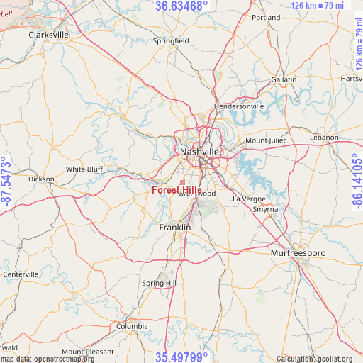
Forest Hills GPS coordinates[2]
36° 4' 6.204" North, 86° 50' 39.012" West
| Map corner | latitude | longitude |
|---|---|---|
| Upper-left | 36.63468°, | -87.5473° |
| Center: | 36.06839°, | -86.84417° |
| Lower-right: | 35.49799°, | -86.14105° |
| Map W x H: | 126.4×126.4 km | = 78.5×78.5mi |
| max Lat: | 71.29058° ⇑70.1% North |
| Forest Hills: | 36.06839° |
| min Lat: | ⇓29.9% South 19.06759° |
| min Long | Forest Hills | max Long |
| -171.73463° | -86.84417° | -66.98998° |
| W 50.7%⇐ | ⇒49.3% E |
Elevation
Elevation of Forest Hills is 203 m = 666 ft, and this is 91.8 m = 301 ft below average elevation for this country.
| Max E: |
3189 m = 10463 ft | 48.8% |
| Avg. | 294.8 m = 967 ft | |
| Forest Hills | 203 m = 666 ft | |
Min E: |
-60 m = -197 ft | 51.2% |
See also: United States elevation on elevation.city.
Geographical zone
Forest Hills is located in North temperate zone (between Tropic of Cancer and the Arctic Circle). Distance of this Northern Tropic circle is 1404.5 km =872.7 mi to South.| Distance of | km | miles | from Forest Hills |
|---|---|---|---|
| North Pole | 5996.6 | 3726.1 | to North |
| Arctic Circle | 3390.7 | 2106.9 | to North |
| Tropic Cancer | 1404.5 | 872.7 | to South |
| Equator | 4010.4 | 2491.9 | to South |


Nearby cities:
15 places around Forest Hills: (largest is in red/bold)
• Ashland City
30.2 km =18.8 mi,  319°
319°
• Belle Meade
3.3 km =2.1 mi,  339°
339°
• Berry Hill
8.8 km =5.5 mi,  52°
52°
• Brentwood
6.8 km =4.2 mi,  125°
125°
• Brentwood Estates
7.6 km =4.7 mi, 129°
• Fairview
26.7 km =16.6 mi,  248°
248°
• Franklin
16.1 km =10 mi,  187°
187°
• Kingston Springs
24.6 km =15.3 mi,  278°
278°
• La Vergne
24.3 km =15.1 mi,  103°
103°
• Lakewood
27 km =16.8 mi,  43°
43°
• Nashville
12.1 km =7.5 mi,  26°
26°
• Nolensville
20.3 km =12.6 mi, 129°
• Oak Hill
5.9 km =3.7 mi,  68°
68°
• Pegram
18.9 km =11.7 mi, 280°
• Thompson's Station
30.2 km =18.8 mi, 191°
Sources, notices
• [Note1] Compared only with cities in United States existing in our database
• [Src1] Map data: © OpenStreetMap contributors (CC-BY-SA)
• [Src2] Other city data from geonames.org with taken over terms of usage.
• [Src3] Geographical zone / Annual Mean Temperature by Robert A. Rohde @ Wikipedia
