Nashville geodata
Nashville (Tennessee) is a seat of a first-order administrative division; located in United States in America/Chicago (GMT-5) time zone. With population of 530,852 people, there are 37 cities with bigger population in this country. Compared to other cities in United States, 69.6% of cities are located further ↑North; 50.8% of cities are located further ←West and 56.9% of cities have higher elevation than Nashville. Note1


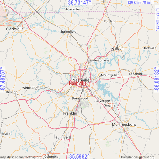
Nashville GPS coordinates[2]
36° 9' 57.204" North, 86° 47' 3.984" West
| Map corner | latitude | longitude |
|---|---|---|
| Upper-left | 36.73147°, | -87.48757° |
| Center: | 36.16589°, | -86.78444° |
| Lower-right: | 35.5962°, | -86.08132° |
| Map W x H: | 126.2×126.2 km | = 78.4×78.4mi |
| max Lat: | 71.29058° ⇑69.6% North |
| Nashville: | 36.16589° |
| min Lat: | ⇓30.4% South 19.06759° |
| min Long | Nashville | max Long |
| -171.73463° | -86.78444° | -66.98998° |
| W 50.8%⇐ | ⇒49.2% E |
Elevation
Elevation of Nashville is 171 m = 561 ft, and this is 123.8 m = 406 ft below average elevation for this country.
| Max E: |
3189 m = 10463 ft | 56.9% |
| Avg. | 294.8 m = 967 ft | |
| Nashville | 171 m = 561 ft | |
Min E: |
-60 m = -197 ft | 43.1% |
See also: Nashville elevation on elevation.city.
Geographical zone
Nashville is located in North temperate zone (between Tropic of Cancer and the Arctic Circle). Distance of this Northern Tropic circle is 1415.4 km =879.5 mi to South.| Distance of | km | miles | from Nashville |
|---|---|---|---|
| North Pole | 5985.8 | 3719.4 | to North |
| Arctic Circle | 3379.9 | 2100.2 | to North |
| Tropic Cancer | 1415.4 | 879.5 | to South |
| Equator | 4021.3 | 2498.7 | to South |


Nearby cities:
15 places around Nashville: (largest is in red/bold)
• Belle Meade
10.1 km =6.3 mi,  219°
219°
• Berry Hill
5.7 km =3.5 mi,  163°
163°
• Brentwood
14.8 km =9.2 mi,  179°
179°
• Brentwood Estates
15.7 km =9.8 mi, 178°
• Forest Hills
12.1 km =7.5 mi,  206°
206°
• Goodlettsville
18.6 km =11.6 mi,  20°
20°
• Green Hill
22 km =13.7 mi,  73°
73°
• Hendersonville
21.4 km =13.3 mi,  43°
43°
• La Vergne
24.7 km =15.3 mi,  132°
132°
• Lakewood
15.9 km =9.9 mi,  57°
57°
• Millersville
23.8 km =14.8 mi, 16°
• Mount Juliet
24.2 km =15 mi,  80°
80°
• Oak Hill
8.7 km =5.4 mi, 179°
• Pegram
25 km =15.5 mi,  253°
253°
• Ridgetop
25.5 km =15.8 mi,  1°
1°
Sources, notices
• [Note1] Compared only with cities in United States existing in our database
• [Src1] Map data: © OpenStreetMap contributors (CC-BY-SA)
• [Src2] Other city data from geonames.org with taken over terms of usage.
• [Src3] Geographical zone / Annual Mean Temperature by Robert A. Rohde @ Wikipedia
