Blountville geodata
Blountville (Tennessee) is a seat of a second-order administrative division; located in United States in America/New_York (GMT-4) time zone. With population of 3,074 people, there are 9515 cities with bigger population in this country. Compared to other cities in United States, 67.9% of cities are located further ↑North; 64.5% of cities are located further ←West and 87% of cities have lower elevation than Blountville. Note1


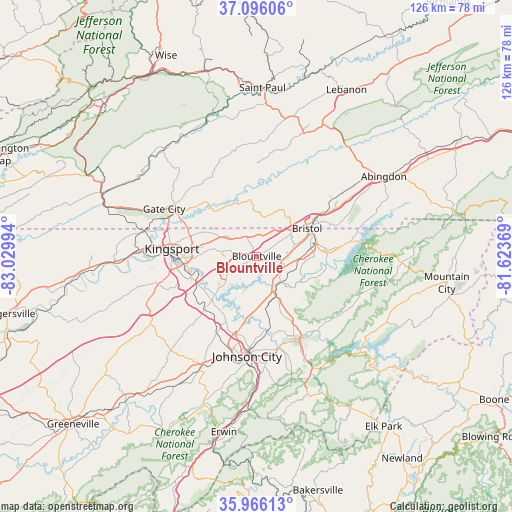
Blountville GPS coordinates[2]
36° 31' 59.376" North, 82° 19' 36.516" West
| Map corner | latitude | longitude |
|---|---|---|
| Upper-left | 37.09606°, | -83.02994° |
| Center: | 36.53316°, | -82.32681° |
| Lower-right: | 35.96613°, | -81.62369° |
| Map W x H: | 125.6×125.6 km | = 78×78mi |
| max Lat: | 71.29058° ⇑67.9% North |
| Blountville: | 36.53316° |
| min Lat: | ⇓32.1% South 19.06759° |
| min Long | Blountville | max Long |
| -171.73463° | -82.32681° | -66.98998° |
| W 64.5%⇐ | ⇒35.5% E |
Elevation
Elevation of Blountville is 469 m = 1539 ft, and this is 174.2 m = 572 ft above average elevation for this country.
| Max E: |
3189 m = 10463 ft | 13% |
| Blountville | 469 m 1539 ft | |
| Avg. | 294.8 m = 967 ft | |
Min E: |
-60 m = -197 ft | 87% |
See also: United States elevation on elevation.city.
Geographical zone
Blountville is located in North temperate zone (between Tropic of Cancer and the Arctic Circle). Distance of this Northern Tropic circle is 1456.2 km =904.8 mi to South.| Distance of | km | miles | from Blountville |
|---|---|---|---|
| North Pole | 5945 | 3694.1 | to North |
| Arctic Circle | 3339.1 | 2074.8 | to North |
| Tropic Cancer | 1456.2 | 904.8 | to South |
| Equator | 4062.1 | 2524.1 | to South |


Nearby cities:
15 places around Blountville: (largest is in red/bold)
• Bloomingdale
15.6 km =9.7 mi,  291°
291°
• Bluff City
8.8 km =5.5 mi,  138°
138°
• Bristol
14.1 km =8.8 mi,  60°
60°
• Bristol
14.2 km =8.8 mi, 60°
• Central
23.2 km =14.4 mi,  171°
171°
• Colonial Heights
16.6 km =10.3 mi,  251°
251°
• Elizabethton
23 km =14.3 mi,  153°
153°
• Fairmount
15.1 km =9.4 mi,  67°
67°
• Gray
18.4 km =11.4 mi,  226°
226°
• Hunter
23.4 km =14.5 mi, 140°
• Kingsport
21.1 km =13.1 mi,  274°
274°
• Oak Grove
16.1 km =10 mi,  212°
212°
• Spurgeon
15.5 km =9.6 mi, 227°
• Walnut Hill
7.5 km =4.7 mi, 56°
• Weber City
23.3 km =14.5 mi,  295°
295°
Sources, notices
• [Note1] Compared only with cities in United States existing in our database
• [Src1] Map data: © OpenStreetMap contributors (CC-BY-SA)
• [Src2] Other city data from geonames.org with taken over terms of usage.
• [Src3] Geographical zone / Annual Mean Temperature by Robert A. Rohde @ Wikipedia
