Bristol geodata
Bristol (Tennessee) is a populated place; located in United States in America/New_York (GMT-4) time zone. With population of 26,666 people, there are 1879 cities with bigger population in this country. Compared to other cities in United States, 67.7% of cities are located further ↑North; 65% of cities are located further ←West and 88.1% of cities have lower elevation than Bristol. Note1


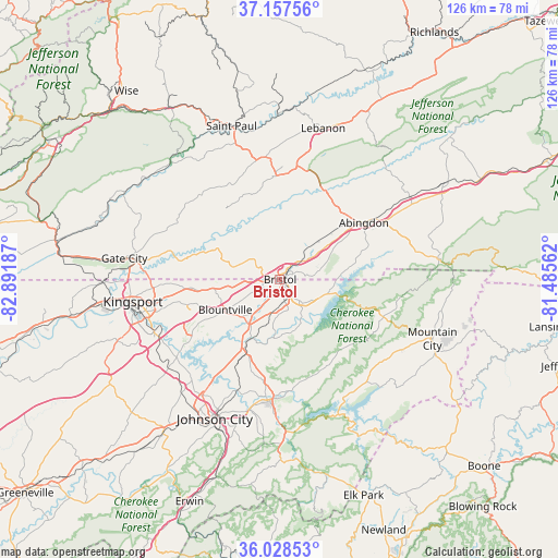
Bristol GPS coordinates[2]
36° 35' 42.396" North, 82° 11' 19.464" West
| Map corner | latitude | longitude |
|---|---|---|
| Upper-left | 37.15756°, | -82.89187° |
| Center: | 36.59511°, | -82.18874° |
| Lower-right: | 36.02853°, | -81.48562° |
| Map W x H: | 125.5×125.5 km | = 78×78mi |
| max Lat: | 71.29058° ⇑67.7% North |
| Bristol: | 36.59511° |
| min Lat: | ⇓32.3% South 19.06759° |
| min Long | Bristol | max Long |
| -171.73463° | -82.18874° | -66.98998° |
| W 65%⇐ | ⇒35% E |
Elevation
Elevation of Bristol is 509 m = 1670 ft, and this is 214.2 m = 703 ft above average elevation for this country.
| Max E: |
3189 m = 10463 ft | 11.9% |
| Bristol | 509 m 1670 ft | |
| Avg. | 294.8 m = 967 ft | |
Min E: |
-60 m = -197 ft | 88.1% |
See also: United States elevation on elevation.city.
Geographical zone
Bristol is located in North temperate zone (between Tropic of Cancer and the Arctic Circle). Distance of this Northern Tropic circle is 1463.1 km =909.1 mi to South.| Distance of | km | miles | from Bristol |
|---|---|---|---|
| North Pole | 5938.1 | 3689.8 | to North |
| Arctic Circle | 3332.2 | 2070.5 | to North |
| Tropic Cancer | 1463.1 | 909.1 | to South |
| Equator | 4069 | 2528.4 | to South |


Nearby cities:
15 places around Bristol: (largest is in red/bold)
• Abingdon
22.8 km =14.2 mi,  55°
55°
• Bloomingdale
26.9 km =16.7 mi,  267°
267°
• Blountville
14.1 km =8.8 mi,  240°
240°
• Bluff City
14.9 km =9.3 mi,  205°
205°
• Bristol
0.2 km =0.1 mi,  8°
8°
• Central
31.2 km =19.4 mi,  196°
196°
• Colonial Heights
30.6 km =19 mi,  246°
246°
• Elizabethton
27.5 km =17.1 mi,  184°
184°
• Fairmount
1.9 km =1.2 mi,  125°
125°
• Gray
32.3 km =20.1 mi,  232°
232°
• Hunter
25 km =15.5 mi,  173°
173°
• Oak Grove
29.3 km =18.2 mi, 225°
• Spurgeon
29.5 km =18.3 mi, 234°
• Walnut Hill
6.7 km =4.2 mi, 245°
• Weber City
33.5 km =20.8 mi,  275°
275°
Sources, notices
• [Note1] Compared only with cities in United States existing in our database
• [Src1] Map data: © OpenStreetMap contributors (CC-BY-SA)
• [Src2] Other city data from geonames.org with taken over terms of usage.
• [Src3] Geographical zone / Annual Mean Temperature by Robert A. Rohde @ Wikipedia
