Kingsport geodata
Kingsport (Tennessee) is a populated place; located in United States in America/New_York (GMT-4) time zone. With population of 53,014 people, there are 879 cities with bigger population in this country. Compared to other cities in United States, 67.9% of cities are located further ↑North; 63.5% of cities are located further ←West and 81.4% of cities have lower elevation than Kingsport. Note1


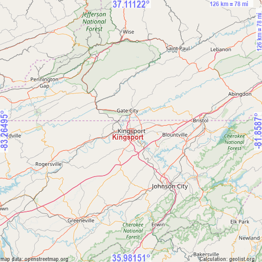
Kingsport GPS coordinates[2]
36° 32' 54.348" North, 82° 33' 42.552" West
| Map corner | latitude | longitude |
|---|---|---|
| Upper-left | 37.11122°, | -83.26495° |
| Center: | 36.54843°, | -82.56182° |
| Lower-right: | 35.98151°, | -81.8587° |
| Map W x H: | 125.6×125.6 km | = 78×78mi |
| max Lat: | 71.29058° ⇑67.9% North |
| Kingsport: | 36.54843° |
| min Lat: | ⇓32.1% South 19.06759° |
| min Long | Kingsport | max Long |
| -171.73463° | -82.56182° | -66.98998° |
| W 63.5%⇐ | ⇒36.5% E |
Elevation
Elevation of Kingsport is 369 m = 1211 ft, and this is 74.2 m = 243 ft above average elevation for this country.
| Max E: |
3189 m = 10463 ft | 18.6% |
| Kingsport | 369 m 1211 ft | |
| Avg. | 294.8 m = 967 ft | |
Min E: |
-60 m = -197 ft | 81.4% |
See also: Kingsport elevation on elevation.city.
Geographical zone
Kingsport is located in North temperate zone (between Tropic of Cancer and the Arctic Circle). Distance of this Northern Tropic circle is 1457.9 km =905.9 mi to South.| Distance of | km | miles | from Kingsport |
|---|---|---|---|
| North Pole | 5943.3 | 3693 | to North |
| Arctic Circle | 3337.4 | 2073.8 | to North |
| Tropic Cancer | 1457.9 | 905.9 | to South |
| Equator | 4063.8 | 2525.1 | to South |


Nearby cities:
15 places around Kingsport: (largest is in red/bold)
• Bloomingdale
7.6 km =4.7 mi,  58°
58°
• Blountville
21.1 km =13.1 mi,  94°
94°
• Bluff City
28.1 km =17.5 mi,  107°
107°
• Church Hill
13.9 km =8.6 mi,  257°
257°
• Colonial Heights
8.8 km =5.5 mi,  143°
143°
• Fall Branch
15.5 km =9.6 mi,  200°
200°
• Gate City
10.1 km =6.3 mi,  350°
350°
• Gray
16.2 km =10.1 mi,  151°
151°
• Jonesborough
29.3 km =18.2 mi,  164°
164°
• Mount Carmel
8.9 km =5.5 mi,  267°
267°
• Oak Grove
19.5 km =12.1 mi, 141°
• Spurgeon
15.4 km =9.6 mi, 141°
• Surgoinsville
27.3 km =17 mi,  251°
251°
• Walnut Hill
27.3 km =17 mi, 85°
• Weber City
8.3 km =5.2 mi,  359°
359°
Sources, notices
• [Note1] Compared only with cities in United States existing in our database
• [Src1] Map data: © OpenStreetMap contributors (CC-BY-SA)
• [Src2] Other city data from geonames.org with taken over terms of usage.
• [Src3] Geographical zone / Annual Mean Temperature by Robert A. Rohde @ Wikipedia
