Abingdon geodata
Abingdon (Virginia) is a seat of a second-order administrative division; located in United States in America/New_York (GMT-4) time zone. With population of 8,119 people, there are 5226 cities with bigger population in this country. Compared to other cities in United States, 67.3% of cities are located further ↑North; 65.6% of cities are located further ←West and 90.2% of cities have lower elevation than Abingdon. Note1


Abingdon GPS coordinates[2]
36° 42' 35.388" North, 81° 58' 38.46" West
| Map corner | latitude | longitude |
|---|---|---|
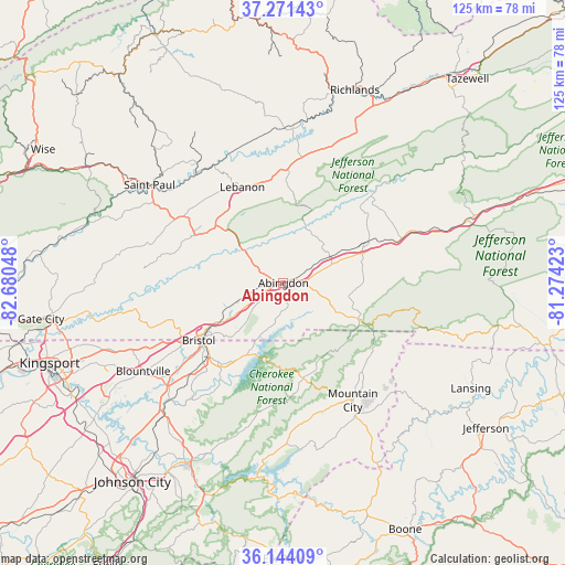
| Upper-left | 37.27143°, | -82.68048° |
| Center: | 36.70983°, | -81.97735° |
| Lower-right: | 36.14409°, | -81.27423° |
| Map W x H: | 125.3×125.3 km | = 77.9×77.9mi |
| max Lat: | 71.29058° ⇑67.3% North |
| Abingdon: | 36.70983° |
| min Lat: | ⇓32.7% South 19.06759° |
| min Long | Abingdon | max Long |
| -171.73463° | -81.97735° | -66.98998° |
| W 65.6%⇐ | ⇒34.4% E |
Elevation
Elevation of Abingdon is 638 m = 2093 ft, and this is 343.2 m = 1126 ft above average elevation for this country.
| Max E: |
3189 m = 10463 ft | 9.8% |
| Abingdon | 638 m 2093 ft | |
| Avg. | 294.8 m = 967 ft | |
Min E: |
-60 m = -197 ft | 90.2% |
See also: United States elevation on elevation.city.
Geographical zone
Abingdon is located in North temperate zone (between Tropic of Cancer and the Arctic Circle). Distance of this Northern Tropic circle is 1475.8 km =917 mi to South.| Distance of | km | miles | from Abingdon |
|---|---|---|---|
| North Pole | 5925.3 | 3681.8 | to North |
| Arctic Circle | 3319.4 | 2062.6 | to North |
| Tropic Cancer | 1475.8 | 917 | to South |
| Equator | 4081.8 | 2536.3 | to South |


Nearby cities:
15 places around Abingdon: (largest is in red/bold)
• Bristol
22.7 km =14.1 mi,  236°
236°
• Bristol
22.8 km =14.2 mi, 235°
• Castlewood
33.6 km =20.9 mi,  306°
306°
• Chilhowie
28.1 km =17.5 mi,  69°
69°
• Damascus
19.2 km =11.9 mi,  116°
116°
• Emory
14.4 km =8.9 mi,  60°
60°
• Fairmount
22.2 km =13.8 mi,  231°
231°
• Glade Spring
20.5 km =12.7 mi, 63°
• Honaker
34.1 km =21.2 mi,  0°
0°
• Lebanon
23.1 km =14.4 mi,  336°
336°
• Meadowview
11.6 km =7.2 mi, 61°
• Mountain City
30.4 km =18.9 mi,  149°
149°
• Saltville
27.1 km =16.8 mi,  45°
45°
• Seven Mile Ford
32.9 km =20.4 mi, 70°
• Walnut Hill
29.4 km =18.3 mi, 238°
Sources, notices
• [Note1] Compared only with cities in United States existing in our database
• [Src1] Map data: © OpenStreetMap contributors (CC-BY-SA)
• [Src2] Other city data from geonames.org with taken over terms of usage.
• [Src3] Geographical zone / Annual Mean Temperature by Robert A. Rohde @ Wikipedia
