Soddy-Daisy geodata
Soddy-Daisy (Tennessee) is a populated place; located in United States in America/New_York (GMT-4) time zone. With population of 13,171 people, there are 3629 cities with bigger population in this country. Compared to other cities in United States, 74.1% of cities are located further ↑North; 55.4% of cities are located further ←West and 53.2% of cities have lower elevation than Soddy-Daisy. Note1


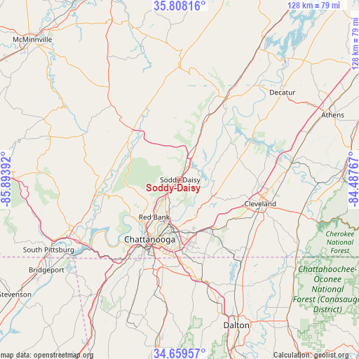
Soddy-Daisy GPS coordinates[2]
35° 14' 9.24" North, 85° 11' 26.844" West
| Map corner | latitude | longitude |
|---|---|---|
| Upper-left | 35.80816°, | -85.89392° |
| Center: | 35.2359°, | -85.19079° |
| Lower-right: | 34.65957°, | -84.48767° |
| Map W x H: | 127.7×127.7 km | = 79.3×79.3mi |
| max Lat: | 71.29058° ⇑74.1% North |
| Soddy-Daisy: | 35.2359° |
| min Lat: | ⇓25.9% South 19.06759° |
| min Long | Soddy-Daisy | max Long |
| -171.73463° | -85.19079° | -66.98998° |
| W 55.4%⇐ | ⇒44.6% E |
Elevation
Elevation of Soddy-Daisy is 211 m = 692 ft, and this is 83.8 m = 275 ft below average elevation for this country.
| Max E: |
3189 m = 10463 ft | 46.8% |
| Avg. | 294.8 m = 967 ft | |
| Soddy-Daisy | 211 m = 692 ft | |
Min E: |
-60 m = -197 ft | 53.2% |
See also: United States elevation on elevation.city.
Geographical zone
Soddy-Daisy is located in North temperate zone (between Tropic of Cancer and the Arctic Circle). Distance of this Northern Tropic circle is 1311.9 km =815.2 mi to South.| Distance of | km | miles | from Soddy-Daisy |
|---|---|---|---|
| North Pole | 6089.2 | 3783.7 | to North |
| Arctic Circle | 3483.3 | 2164.4 | to North |
| Tropic Cancer | 1311.9 | 815.2 | to South |
| Equator | 3917.9 | 2434.5 | to South |


Nearby cities:
15 places around Soddy-Daisy: (largest is in red/bold)
• Chattanooga
23.8 km =14.8 mi,  207°
207°
• Dunlap
23.6 km =14.7 mi,  309°
309°
• East Chattanooga
19.7 km =12.2 mi,  195°
195°
• Fairmount
13.5 km =8.4 mi,  243°
243°
• Falling Water
6.8 km =4.2 mi, 237°
• Harrison
14.4 km =8.9 mi,  160°
160°
• Lakesite
6.5 km =4 mi,  117°
117°
• Lone Oak
16.2 km =10.1 mi,  256°
256°
• Middle Valley
4.5 km =2.8 mi,  172°
172°
• Mowbray Mountain
5.2 km =3.2 mi,  326°
326°
• Ooltewah
21.4 km =13.3 mi,  146°
146°
• Red Bank
16.6 km =10.3 mi, 214°
• Sale Creek
17.9 km =11.1 mi,  24°
24°
• Signal Mountain
18.8 km =11.7 mi,  227°
227°
• Walden
12.8 km =8 mi, 231°
Sources, notices
• [Note1] Compared only with cities in United States existing in our database
• [Src1] Map data: © OpenStreetMap contributors (CC-BY-SA)
• [Src2] Other city data from geonames.org with taken over terms of usage.
• [Src3] Geographical zone / Annual Mean Temperature by Robert A. Rohde @ Wikipedia
