Doyle geodata
Doyle (Tennessee) is a populated place; located in United States in America/Chicago (GMT-5) time zone. With population of 545 people, there are 20332 cities with bigger population in this country. Compared to other cities in United States, 71.1% of cities are located further ↑North; 54.6% of cities are located further ←West and 70.4% of cities have lower elevation than Doyle. Note1


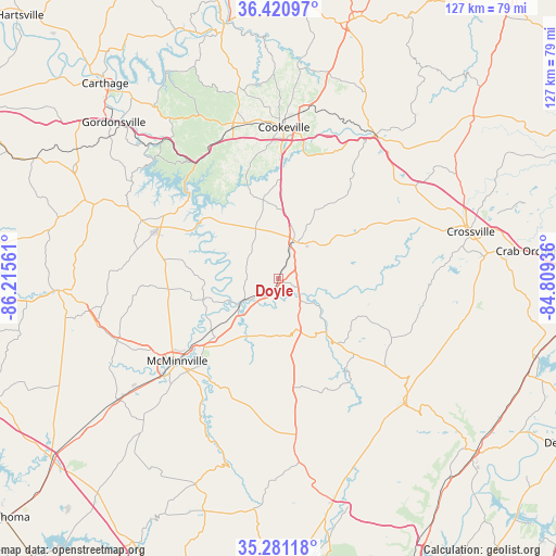
Doyle GPS coordinates[2]
35° 51' 11.232" North, 85° 30' 44.928" West
| Map corner | latitude | longitude |
|---|---|---|
| Upper-left | 36.42097°, | -86.21561° |
| Center: | 35.85312°, | -85.51248° |
| Lower-right: | 35.28118°, | -84.80936° |
| Map W x H: | 126.7×126.7 km | = 78.7×78.7mi |
| max Lat: | 71.29058° ⇑71.1% North |
| Doyle: | 35.85312° |
| min Lat: | ⇓28.9% South 19.06759° |
| min Long | Doyle | max Long |
| -171.73463° | -85.51248° | -66.98998° |
| W 54.6%⇐ | ⇒45.4% E |
Elevation
Elevation of Doyle is 288 m = 945 ft, and this is 6.8 m = 22 ft below average elevation for this country.
| Max E: |
3189 m = 10463 ft | 29.6% |
| Avg. | 294.8 m = 967 ft | |
| Doyle | 288 m = 945 ft | |
Min E: |
-60 m = -197 ft | 70.4% |
See also: United States elevation on elevation.city.
Geographical zone
Doyle is located in North temperate zone (between Tropic of Cancer and the Arctic Circle). Distance of this Northern Tropic circle is 1380.6 km =857.9 mi to South.| Distance of | km | miles | from Doyle |
|---|---|---|---|
| North Pole | 6020.6 | 3741 | to North |
| Arctic Circle | 3414.7 | 2121.8 | to North |
| Tropic Cancer | 1380.6 | 857.9 | to South |
| Equator | 3986.5 | 2477.1 | to South |


Nearby cities:
15 places around Doyle: (largest is in red/bold)
• Algood
38.5 km =23.9 mi,  8°
8°
• Baxter
35.4 km =22 mi,  340°
340°
• Cookeville
34.5 km =21.4 mi,  1°
1°
• Crossville
45 km =28 mi,  76°
76°
• Lafayette
41.3 km =25.7 mi,  333°
333°
• Lake Tansi
41.3 km =25.7 mi,  86°
86°
• McMinnville
29.9 km =18.6 mi,  230°
230°
• Monterey
39.4 km =24.5 mi,  33°
33°
• Morrison
46.1 km =28.6 mi, 232°
• Pikeville
40.1 km =24.9 mi,  133°
133°
• Pleasant Hill
31.8 km =19.8 mi,  64°
64°
• Smithville
29.7 km =18.5 mi,  293°
293°
• Sparta
9.2 km =5.7 mi, 28°
• Spencer
12.5 km =7.8 mi,  160°
160°
• Woodbury
50.5 km =31.4 mi,  266°
266°
Sources, notices
• [Note1] Compared only with cities in United States existing in our database
• [Src1] Map data: © OpenStreetMap contributors (CC-BY-SA)
• [Src2] Other city data from geonames.org with taken over terms of usage.
• [Src3] Geographical zone / Annual Mean Temperature by Robert A. Rohde @ Wikipedia
