Monterey geodata
Monterey (Tennessee) is a populated place; located in United States in America/Chicago (GMT-5) time zone. With population of 2,860 people, there are 9891 cities with bigger population in this country. Compared to other cities in United States, 69.7% of cities are located further ↑North; 55.2% of cities are located further ←West and 89.2% of cities have lower elevation than Monterey. Note1


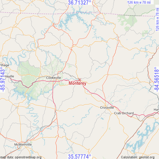
Monterey GPS coordinates[2]
36° 8' 51.216" North, 85° 16' 5.88" West
| Map corner | latitude | longitude |
|---|---|---|
| Upper-left | 36.71327°, | -85.97143° |
| Center: | 36.14756°, | -85.2683° |
| Lower-right: | 35.57774°, | -84.56518° |
| Map W x H: | 126.3×126.3 km | = 78.5×78.5mi |
| max Lat: | 71.29058° ⇑69.7% North |
| Monterey: | 36.14756° |
| min Lat: | ⇓30.3% South 19.06759° |
| min Long | Monterey | max Long |
| -171.73463° | -85.2683° | -66.98998° |
| W 55.2%⇐ | ⇒44.8% E |
Elevation
Elevation of Monterey is 574 m = 1883 ft, and this is 279.2 m = 916 ft above average elevation for this country.
| Max E: |
3189 m = 10463 ft | 10.8% |
| Monterey | 574 m 1883 ft | |
| Avg. | 294.8 m = 967 ft | |
Min E: |
-60 m = -197 ft | 89.2% |
See also: United States elevation on elevation.city.
Geographical zone
Monterey is located in North temperate zone (between Tropic of Cancer and the Arctic Circle). Distance of this Northern Tropic circle is 1413.3 km =878.2 mi to South.| Distance of | km | miles | from Monterey |
|---|---|---|---|
| North Pole | 5987.8 | 3720.6 | to North |
| Arctic Circle | 3381.9 | 2101.4 | to North |
| Tropic Cancer | 1413.3 | 878.2 | to South |
| Equator | 4019.2 | 2497.4 | to South |


Nearby cities:
15 places around Monterey: (largest is in red/bold)
• Algood
17.1 km =10.6 mi,  288°
288°
• Baxter
33.7 km =20.9 mi,  271°
271°
• Clarkrange
22.9 km =14.2 mi,  79°
79°
• Cookeville
21 km =13 mi, 274°
• Crossville
31 km =19.3 mi,  135°
135°
• Dodson Branch
29.9 km =18.6 mi,  307°
307°
• Doyle
39.4 km =24.5 mi,  213°
213°
• Fairfield Glade
38 km =23.6 mi,  115°
115°
• Gainesboro
42 km =26.1 mi,  303°
303°
• Grimsley
28.7 km =17.8 mi,  62°
62°
• Lafayette
40.4 km =25.1 mi,  276°
276°
• Lake Tansi
36.1 km =22.4 mi,  147°
147°
• Livingston
26.7 km =16.6 mi,  349°
349°
• Pleasant Hill
20.2 km =12.6 mi,  160°
160°
• Sparta
30.3 km =18.8 mi,  215°
215°
Sources, notices
• [Note1] Compared only with cities in United States existing in our database
• [Src1] Map data: © OpenStreetMap contributors (CC-BY-SA)
• [Src2] Other city data from geonames.org with taken over terms of usage.
• [Src3] Geographical zone / Annual Mean Temperature by Robert A. Rohde @ Wikipedia
