Woodbury geodata
Woodbury (Tennessee) is a seat of a second-order administrative division; located in United States in America/Chicago (GMT-5) time zone. With population of 2,762 people, there are 10057 cities with bigger population in this country. Compared to other cities in United States, 71.2% of cities are located further ↑North; 52.7% of cities are located further ←West and 55.8% of cities have lower elevation than Woodbury. Note1


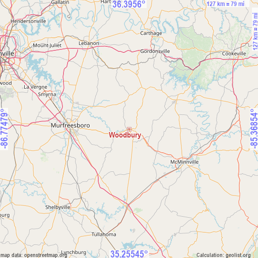
Woodbury GPS coordinates[2]
35° 49' 39.252" North, 86° 4' 17.976" West
| Map corner | latitude | longitude |
|---|---|---|
| Upper-left | 36.3956°, | -86.77479° |
| Center: | 35.82757°, | -86.07166° |
| Lower-right: | 35.25545°, | -85.36854° |
| Map W x H: | 126.8×126.8 km | = 78.8×78.8mi |
| max Lat: | 71.29058° ⇑71.2% North |
| Woodbury: | 35.82757° |
| min Lat: | ⇓28.8% South 19.06759° |
| min Long | Woodbury | max Long |
| -171.73463° | -86.07166° | -66.98998° |
| W 52.7%⇐ | ⇒47.3% E |
Elevation
Elevation of Woodbury is 222 m = 728 ft, and this is 72.8 m = 239 ft below average elevation for this country.
| Max E: |
3189 m = 10463 ft | 44.2% |
| Avg. | 294.8 m = 967 ft | |
| Woodbury | 222 m = 728 ft | |
Min E: |
-60 m = -197 ft | 55.8% |
See also: United States elevation on elevation.city.
Geographical zone
Woodbury is located in North temperate zone (between Tropic of Cancer and the Arctic Circle). Distance of this Northern Tropic circle is 1377.7 km =856.1 mi to South.| Distance of | km | miles | from Woodbury |
|---|---|---|---|
| North Pole | 6023.4 | 3742.8 | to North |
| Arctic Circle | 3417.5 | 2123.5 | to North |
| Tropic Cancer | 1377.7 | 856.1 | to South |
| Equator | 3983.7 | 2475.4 | to South |


Nearby cities:
15 places around Woodbury: (largest is in red/bold)
• Alexandria
28 km =17.4 mi,  7°
7°
• Bell Buckle
36.6 km =22.7 mi,  224°
224°
• Christiana
32.3 km =20.1 mi,  246°
246°
• Gordonsville
40.4 km =25.1 mi,  18°
18°
• Lakewood Park
20.7 km =12.9 mi,  196°
196°
• Lebanon
46.7 km =29 mi,  334°
334°
• Manchester
38.5 km =23.9 mi,  182°
182°
• McMinnville
31.6 km =19.6 mi,  120°
120°
• Morrison
28.5 km =17.7 mi,  151°
151°
• Murfreesboro
28.8 km =17.9 mi,  273°
273°
• New Union
32.8 km =20.4 mi, 181°
• Smithville
27.5 km =17.1 mi,  57°
57°
• Smyrna
43.8 km =27.2 mi,  293°
293°
• Wartrace
40.9 km =25.4 mi, 215°
• Watertown
30.8 km =19.1 mi,  349°
349°
Sources, notices
• [Note1] Compared only with cities in United States existing in our database
• [Src1] Map data: © OpenStreetMap contributors (CC-BY-SA)
• [Src2] Other city data from geonames.org with taken over terms of usage.
• [Src3] Geographical zone / Annual Mean Temperature by Robert A. Rohde @ Wikipedia
