Dunlap geodata
Dunlap (Tennessee) is a seat of a second-order administrative division; located in United States in America/Chicago (GMT-5) time zone. With population of 5,108 people, there are 7067 cities with bigger population in this country. Compared to other cities in United States, 73.3% of cities are located further ↑North; 54.9% of cities are located further ←West and 54.7% of cities have lower elevation than Dunlap. Note1


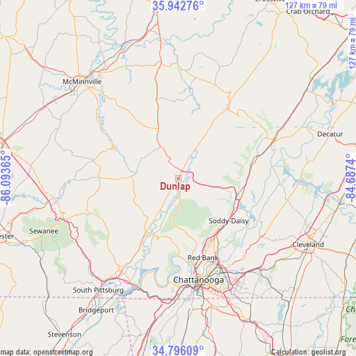
Dunlap GPS coordinates[2]
35° 22' 17.256" North, 85° 23' 25.872" West
| Map corner | latitude | longitude |
|---|---|---|
| Upper-left | 35.94276°, | -86.09365° |
| Center: | 35.37146°, | -85.39052° |
| Lower-right: | 34.79609°, | -84.6874° |
| Map W x H: | 127.5×127.5 km | = 79.2×79.2mi |
| max Lat: | 71.29058° ⇑73.3% North |
| Dunlap: | 35.37146° |
| min Lat: | ⇓26.7% South 19.06759° |
| min Long | Dunlap | max Long |
| -171.73463° | -85.39052° | -66.98998° |
| W 54.9%⇐ | ⇒45.1% E |
Elevation
Elevation of Dunlap is 217 m = 712 ft, and this is 77.8 m = 255 ft below average elevation for this country.
| Max E: |
3189 m = 10463 ft | 45.3% |
| Avg. | 294.8 m = 967 ft | |
| Dunlap | 217 m = 712 ft | |
Min E: |
-60 m = -197 ft | 54.7% |
See also: United States elevation on elevation.city.
Geographical zone
Dunlap is located in North temperate zone (between Tropic of Cancer and the Arctic Circle). Distance of this Northern Tropic circle is 1327 km =824.6 mi to South.| Distance of | km | miles | from Dunlap |
|---|---|---|---|
| North Pole | 6074.1 | 3774.3 | to North |
| Arctic Circle | 3468.2 | 2155 | to North |
| Tropic Cancer | 1327 | 824.6 | to South |
| Equator | 3932.9 | 2443.8 | to South |


Nearby cities:
15 places around Dunlap: (largest is in red/bold)
• Coalmont
28.7 km =17.8 mi,  262°
262°
• Fairmount
22 km =13.7 mi,  163°
163°
• Falling Water
22.5 km =14 mi,  146°
146°
• Graysville
29 km =18 mi,  73°
73°
• Gruetli-Laager
20.6 km =12.8 mi,  270°
270°
• Lone Oak
19.1 km =11.9 mi,  172°
172°
• Middle Valley
27 km =16.8 mi,  136°
136°
• Mowbray Mountain
18.6 km =11.6 mi,  125°
125°
• Palmer
16.2 km =10.1 mi, 262°
• Powells Crossroads
22 km =13.7 mi,  203°
203°
• Sale Creek
25.6 km =15.9 mi,  87°
87°
• Signal Mountain
28 km =17.4 mi, 171°
• Soddy-Daisy
23.6 km =14.7 mi, 129°
• Walden
24.4 km =15.2 mi, 160°
• Whitwell
22.2 km =13.8 mi,  211°
211°
Sources, notices
• [Note1] Compared only with cities in United States existing in our database
• [Src1] Map data: © OpenStreetMap contributors (CC-BY-SA)
• [Src2] Other city data from geonames.org with taken over terms of usage.
• [Src3] Geographical zone / Annual Mean Temperature by Robert A. Rohde @ Wikipedia
