Jacksboro geodata
Jacksboro (Tennessee) is a seat of a second-order administrative division; located in United States in America/New_York (GMT-4) time zone. With population of 1,951 people, there are 12093 cities with bigger population in this country. Compared to other cities in United States, 68.8% of cities are located further ↑North; 58.7% of cities are located further ←West and 76.9% of cities have lower elevation than Jacksboro. Note1


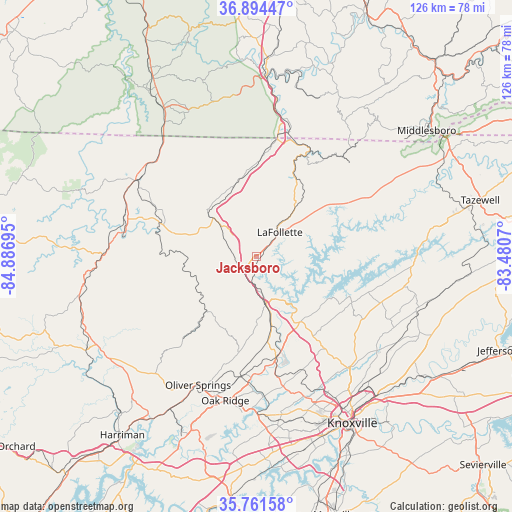
Jacksboro GPS coordinates[2]
36° 19' 48.288" North, 84° 11' 1.752" West
| Map corner | latitude | longitude |
|---|---|---|
| Upper-left | 36.89447°, | -84.88695° |
| Center: | 36.33008°, | -84.18382° |
| Lower-right: | 35.76158°, | -83.4807° |
| Map W x H: | 126×126 km | = 78.3×78.3mi |
| max Lat: | 71.29058° ⇑68.8% North |
| Jacksboro: | 36.33008° |
| min Lat: | ⇓31.2% South 19.06759° |
| min Long | Jacksboro | max Long |
| -171.73463° | -84.18382° | -66.98998° |
| W 58.7%⇐ | ⇒41.3% E |
Elevation
Elevation of Jacksboro is 327 m = 1073 ft, and this is 32.2 m = 106 ft above average elevation for this country.
| Max E: |
3189 m = 10463 ft | 23.1% |
| Jacksboro | 327 m 1073 ft | |
| Avg. | 294.8 m = 967 ft | |
Min E: |
-60 m = -197 ft | 76.9% |
See also: United States elevation on elevation.city.
Geographical zone
Jacksboro is located in North temperate zone (between Tropic of Cancer and the Arctic Circle). Distance of this Northern Tropic circle is 1433.6 km =890.8 mi to South.| Distance of | km | miles | from Jacksboro |
|---|---|---|---|
| North Pole | 5967.5 | 3708 | to North |
| Arctic Circle | 3361.6 | 2088.8 | to North |
| Tropic Cancer | 1433.6 | 890.8 | to South |
| Equator | 4039.5 | 2510 | to South |


Nearby cities:
15 places around Jacksboro: (largest is in red/bold)
• Caryville
4.9 km =3 mi,  225°
225°
• Clinton
25.6 km =15.9 mi,  169°
169°
• Fincastle
15.1 km =9.4 mi,  53°
53°
• Helenwood
34.1 km =21.2 mi,  288°
288°
• Hunter
5.3 km =3.3 mi, 47°
• Huntsville
28.9 km =18 mi, 287°
• Jellico
29.1 km =18.1 mi,  10°
10°
• LaFollette
8.2 km =5.1 mi,  44°
44°
• Norris
18.2 km =11.3 mi,  145°
145°
• Oliver Springs
34.9 km =21.7 mi,  204°
204°
• Oneida
34.9 km =21.7 mi,  302°
302°
• Petros
34.9 km =21.7 mi,  221°
221°
• Pine Crest
7.8 km =4.8 mi,  140°
140°
• Rocky Top
12.7 km =7.9 mi, 168°
• Winfield
34.7 km =21.6 mi,  316°
316°
Sources, notices
• [Note1] Compared only with cities in United States existing in our database
• [Src1] Map data: © OpenStreetMap contributors (CC-BY-SA)
• [Src2] Other city data from geonames.org with taken over terms of usage.
• [Src3] Geographical zone / Annual Mean Temperature by Robert A. Rohde @ Wikipedia
