Rocky Top geodata
Rocky Top (Tennessee) is a populated place; located in United States in America/New_York (GMT-4) time zone. With population of 1,781 people, there are 12620 cities with bigger population in this country. Compared to other cities in United States, 69.3% of cities are located further ↑North; 58.8% of cities are located further ←West and 65.8% of cities have lower elevation than Rocky Top. Note1


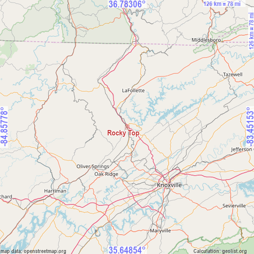
Rocky Top GPS coordinates[2]
36° 13' 4.296" North, 84° 9' 16.74" West
| Map corner | latitude | longitude |
|---|---|---|
| Upper-left | 36.78306°, | -84.85778° |
| Center: | 36.21786°, | -84.15465° |
| Lower-right: | 35.64854°, | -83.45153° |
| Map W x H: | 126.1×126.1 km | = 78.4×78.4mi |
| max Lat: | 71.29058° ⇑69.3% North |
| Rocky Top: | 36.21786° |
| min Lat: | ⇓30.7% South 19.06759° |
| min Long | Rocky Top | max Long |
| -171.73463° | -84.15465° | -66.98998° |
| W 58.8%⇐ | ⇒41.2% E |
Elevation
Elevation of Rocky Top is 266 m = 873 ft, and this is 28.8 m = 94 ft below average elevation for this country.
| Max E: |
3189 m = 10463 ft | 34.2% |
| Avg. | 294.8 m = 967 ft | |
| Rocky Top | 266 m = 873 ft | |
Min E: |
-60 m = -197 ft | 65.8% |
See also: United States elevation on elevation.city.
Geographical zone
Rocky Top is located in North temperate zone (between Tropic of Cancer and the Arctic Circle). Distance of this Northern Tropic circle is 1421.1 km =883 mi to South.| Distance of | km | miles | from Rocky Top |
|---|---|---|---|
| North Pole | 5980 | 3715.8 | to North |
| Arctic Circle | 3374.1 | 2096.6 | to North |
| Tropic Cancer | 1421.1 | 883 | to South |
| Equator | 4027 | 2502.3 | to South |


Nearby cities:
15 places around Rocky Top: (largest is in red/bold)
• Caryville
10.9 km =6.8 mi,  325°
325°
• Clinton
12.9 km =8 mi,  170°
170°
• Coalfield
31.8 km =19.8 mi,  228°
228°
• Condon
32.6 km =20.3 mi,  97°
97°
• Fincastle
23.4 km =14.5 mi,  24°
24°
• Hunter
16.1 km =10 mi,  4°
4°
• Jacksboro
12.7 km =7.9 mi,  348°
348°
• LaFollette
18.6 km =11.6 mi,  9°
9°
• Maynardville
32.2 km =20 mi,  83°
83°
• Norris
8.2 km =5.1 mi,  107°
107°
• Oak Ridge
25.3 km =15.7 mi,  204°
204°
• Oliver Springs
25.7 km =16 mi,  221°
221°
• Petros
29.2 km =18.1 mi,  242°
242°
• Pine Crest
6.9 km =4.3 mi, 19°
• Plainview
32.6 km =20.3 mi, 97°
Sources, notices
• [Note1] Compared only with cities in United States existing in our database
• [Src1] Map data: © OpenStreetMap contributors (CC-BY-SA)
• [Src2] Other city data from geonames.org with taken over terms of usage.
• [Src3] Geographical zone / Annual Mean Temperature by Robert A. Rohde @ Wikipedia
