Jamestown geodata
Jamestown (Tennessee) is a seat of a second-order administrative division; located in United States in America/Chicago (GMT-5) time zone. With population of 1,947 people, there are 12104 cities with bigger population in this country. Compared to other cities in United States, 68.3% of cities are located further ↑North; 56% of cities are located further ←West and 88.4% of cities have lower elevation than Jamestown. Note1


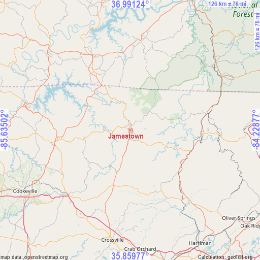
Jamestown GPS coordinates[2]
36° 25' 39.252" North, 84° 55' 54.804" West
| Map corner | latitude | longitude |
|---|---|---|
| Upper-left | 36.99124°, | -85.63502° |
| Center: | 36.42757°, | -84.93189° |
| Lower-right: | 35.85977°, | -84.22877° |
| Map W x H: | 125.8×125.8 km | = 78.2×78.2mi |
| max Lat: | 71.29058° ⇑68.3% North |
| Jamestown: | 36.42757° |
| min Lat: | ⇓31.7% South 19.06759° |
| min Long | Jamestown | max Long |
| -171.73463° | -84.93189° | -66.98998° |
| W 56%⇐ | ⇒44% E |
Elevation
Elevation of Jamestown is 524 m = 1719 ft, and this is 229.2 m = 752 ft above average elevation for this country.
| Max E: |
3189 m = 10463 ft | 11.6% |
| Jamestown | 524 m 1719 ft | |
| Avg. | 294.8 m = 967 ft | |
Min E: |
-60 m = -197 ft | 88.4% |
See also: United States elevation on elevation.city.
Geographical zone
Jamestown is located in North temperate zone (between Tropic of Cancer and the Arctic Circle). Distance of this Northern Tropic circle is 1444.4 km =897.5 mi to South.| Distance of | km | miles | from Jamestown |
|---|---|---|---|
| North Pole | 5956.7 | 3701.3 | to North |
| Arctic Circle | 3350.8 | 2082.1 | to North |
| Tropic Cancer | 1444.4 | 897.5 | to South |
| Equator | 4050.4 | 2516.8 | to South |


Nearby cities:
15 places around Jamestown: (largest is in red/bold)
• Albany
34.4 km =21.4 mi,  328°
328°
• Allardt
6.7 km =4.2 mi,  140°
140°
• Byrdstown
24 km =14.9 mi,  312°
312°
• Clarkrange
28.2 km =17.5 mi,  195°
195°
• Fairfield Glade
47.7 km =29.6 mi,  175°
175°
• Grimsley
18.5 km =11.5 mi,  194°
194°
• Helenwood
34.7 km =21.6 mi,  89°
89°
• Huntsville
39.5 km =24.5 mi, 92°
• Livingston
35.3 km =21.9 mi,  262°
262°
• Monterey
43.3 km =26.9 mi,  224°
224°
• Monticello
45.3 km =28.1 mi,  9°
9°
• Oneida
38.3 km =23.8 mi,  78°
78°
• Sunbright
31.1 km =19.3 mi,  131°
131°
• Wartburg
46.8 km =29.1 mi, 140°
• Winfield
45.2 km =28.1 mi,  71°
71°
Sources, notices
• [Note1] Compared only with cities in United States existing in our database
• [Src1] Map data: © OpenStreetMap contributors (CC-BY-SA)
• [Src2] Other city data from geonames.org with taken over terms of usage.
• [Src3] Geographical zone / Annual Mean Temperature by Robert A. Rohde @ Wikipedia
