Maynardville geodata
Maynardville (Tennessee) is a seat of a second-order administrative division; located in United States in America/New_York (GMT-4) time zone. With population of 2,355 people, there are 10961 cities with bigger population in this country. Compared to other cities in United States, 69.2% of cities are located further ↑North; 59.8% of cities are located further ←West and 81.6% of cities have lower elevation than Maynardville. Note1


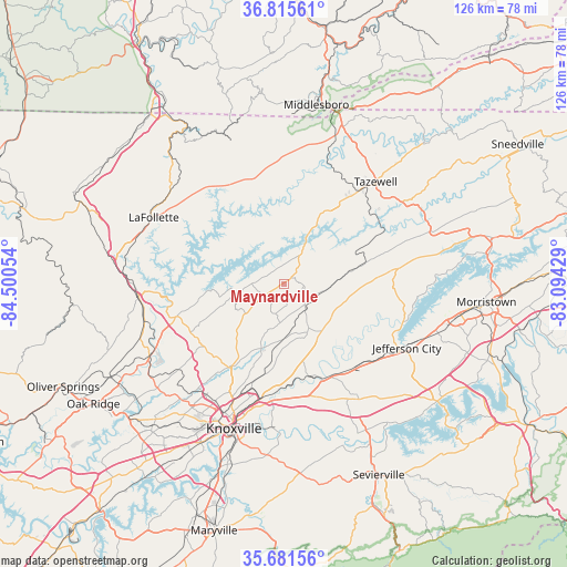
Maynardville GPS coordinates[2]
36° 15' 2.304" North, 83° 47' 50.676" West
| Map corner | latitude | longitude |
|---|---|---|
| Upper-left | 36.81561°, | -84.50054° |
| Center: | 36.25064°, | -83.79741° |
| Lower-right: | 35.68156°, | -83.09429° |
| Map W x H: | 126.1×126.1 km | = 78.4×78.4mi |
| max Lat: | 71.29058° ⇑69.2% North |
| Maynardville: | 36.25064° |
| min Lat: | ⇓30.8% South 19.06759° |
| min Long | Maynardville | max Long |
| -171.73463° | -83.79741° | -66.98998° |
| W 59.8%⇐ | ⇒40.2% E |
Elevation
Elevation of Maynardville is 372 m = 1220 ft, and this is 77.2 m = 253 ft above average elevation for this country.
| Max E: |
3189 m = 10463 ft | 18.4% |
| Maynardville | 372 m 1220 ft | |
| Avg. | 294.8 m = 967 ft | |
Min E: |
-60 m = -197 ft | 81.6% |
See also: United States elevation on elevation.city.
Geographical zone
Maynardville is located in North temperate zone (between Tropic of Cancer and the Arctic Circle). Distance of this Northern Tropic circle is 1424.8 km =885.3 mi to South.| Distance of | km | miles | from Maynardville |
|---|---|---|---|
| North Pole | 5976.4 | 3713.6 | to North |
| Arctic Circle | 3370.5 | 2094.3 | to North |
| Tropic Cancer | 1424.8 | 885.3 | to South |
| Equator | 4030.7 | 2504.6 | to South |


Nearby cities:
15 places around Maynardville: (largest is in red/bold)
• Blaine
13.6 km =8.5 mi,  141°
141°
• Condon
7.7 km =4.8 mi,  177°
177°
• Fincastle
28.6 km =17.8 mi,  308°
308°
• Jefferson City
30.9 km =19.2 mi,  117°
117°
• LaFollette
32.4 km =20.1 mi,  296°
296°
• Luttrell
7.6 km =4.7 mi, 138°
• Mascot
21.6 km =13.4 mi,  167°
167°
• New Market
27.4 km =17 mi,  126°
126°
• New Tazewell
27.7 km =17.2 mi,  39°
39°
• Norris
25 km =15.5 mi,  255°
255°
• Pine Crest
29.8 km =18.5 mi,  275°
275°
• Plainview
8.2 km =5.1 mi, 178°
• Rocky Top
32.2 km =20 mi, 263°
• Rutledge
25.5 km =15.8 mi,  82°
82°
• Tazewell
30.5 km =19 mi, 42°
Sources, notices
• [Note1] Compared only with cities in United States existing in our database
• [Src1] Map data: © OpenStreetMap contributors (CC-BY-SA)
• [Src2] Other city data from geonames.org with taken over terms of usage.
• [Src3] Geographical zone / Annual Mean Temperature by Robert A. Rohde @ Wikipedia
