Mascot geodata
Mascot (Tennessee) is a populated place; located in United States in America/New_York (GMT-4) time zone. With population of 2,411 people, there are 10819 cities with bigger population in this country. Compared to other cities in United States, 70.2% of cities are located further ↑North; 60% of cities are located further ←West and 65.8% of cities have lower elevation than Mascot. Note1


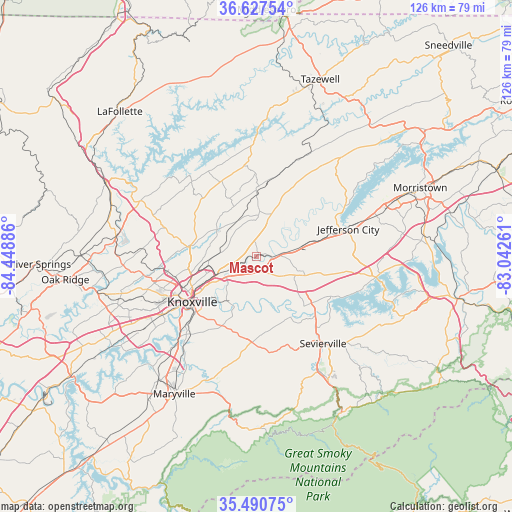
Mascot GPS coordinates[2]
36° 3' 40.32" North, 83° 44' 44.628" West
| Map corner | latitude | longitude |
|---|---|---|
| Upper-left | 36.62754°, | -84.44886° |
| Center: | 36.0612°, | -83.74573° |
| Lower-right: | 35.49075°, | -83.04261° |
| Map W x H: | 126.4×126.4 km | = 78.5×78.5mi |
| max Lat: | 71.29058° ⇑70.2% North |
| Mascot: | 36.0612° |
| min Lat: | ⇓29.8% South 19.06759° |
| min Long | Mascot | max Long |
| -171.73463° | -83.74573° | -66.98998° |
| W 60%⇐ | ⇒40% E |
Elevation
Elevation of Mascot is 266 m = 873 ft, and this is 28.8 m = 94 ft below average elevation for this country.
| Max E: |
3189 m = 10463 ft | 34.2% |
| Avg. | 294.8 m = 967 ft | |
| Mascot | 266 m = 873 ft | |
Min E: |
-60 m = -197 ft | 65.8% |
See also: United States elevation on elevation.city.
Geographical zone
Mascot is located in North temperate zone (between Tropic of Cancer and the Arctic Circle). Distance of this Northern Tropic circle is 1403.7 km =872.2 mi to South.| Distance of | km | miles | from Mascot |
|---|---|---|---|
| North Pole | 5997.4 | 3726.6 | to North |
| Arctic Circle | 3391.5 | 2107.4 | to North |
| Tropic Cancer | 1403.7 | 872.2 | to South |
| Equator | 4009.6 | 2491.4 | to South |


Nearby cities:
15 places around Mascot: (largest is in red/bold)
• Blaine
11 km =6.8 mi,  19°
19°
• Condon
14 km =8.7 mi,  342°
342°
• Dandridge
30.2 km =18.8 mi,  99°
99°
• Jefferson City
23.8 km =14.8 mi,  73°
73°
• Knoxville
19.3 km =12 mi,  234°
234°
• Luttrell
15.4 km =9.6 mi,  1°
1°
• Maynardville
21.6 km =13.4 mi,  347°
347°
• New Market
18 km =11.2 mi, 74°
• Norris
32.6 km =20.3 mi,  297°
297°
• Plainview
13.7 km =8.5 mi, 340°
• Rockford
31.4 km =19.5 mi,  214°
214°
• Rutledge
32 km =19.9 mi,  40°
40°
• Sevierville
27.1 km =16.8 mi,  142°
142°
• Seymour
19.1 km =11.9 mi,  174°
174°
• Wildwood
30.8 km =19.1 mi,  201°
201°
Sources, notices
• [Note1] Compared only with cities in United States existing in our database
• [Src1] Map data: © OpenStreetMap contributors (CC-BY-SA)
• [Src2] Other city data from geonames.org with taken over terms of usage.
• [Src3] Geographical zone / Annual Mean Temperature by Robert A. Rohde @ Wikipedia
