Gainesboro geodata
Gainesboro (Tennessee) is a seat of a second-order administrative division; located in United States in America/Chicago (GMT-5) time zone. With population of 955 people, there are 16605 cities with bigger population in this country. Compared to other cities in United States, 68.7% of cities are located further ↑North; 54% of cities are located further ←West and 55.7% of cities have higher elevation than Gainesboro. Note1


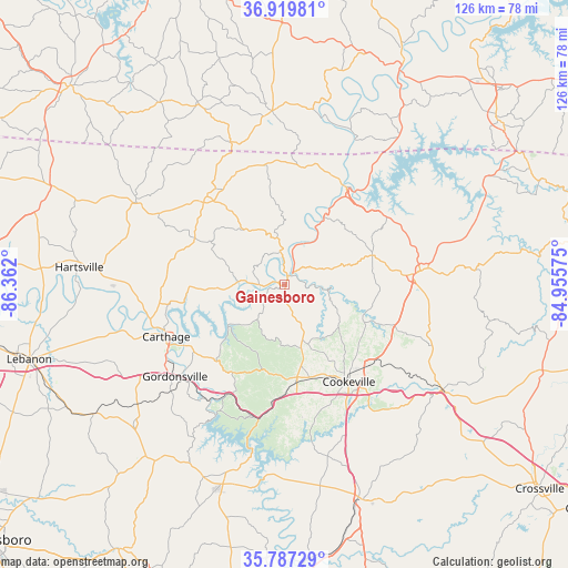
Gainesboro GPS coordinates[2]
36° 21' 20.196" North, 85° 39' 31.932" West
| Map corner | latitude | longitude |
|---|---|---|
| Upper-left | 36.91981°, | -86.362° |
| Center: | 36.35561°, | -85.65887° |
| Lower-right: | 35.78729°, | -84.95575° |
| Map W x H: | 125.9×125.9 km | = 78.2×78.2mi |
| max Lat: | 71.29058° ⇑68.7% North |
| Gainesboro: | 36.35561° |
| min Lat: | ⇓31.3% South 19.06759° |
| min Long | Gainesboro | max Long |
| -171.73463° | -85.65887° | -66.98998° |
| W 54%⇐ | ⇒46% E |
Elevation
Elevation of Gainesboro is 177 m = 581 ft, and this is 117.8 m = 386 ft below average elevation for this country.
| Max E: |
3189 m = 10463 ft | 55.7% |
| Avg. | 294.8 m = 967 ft | |
| Gainesboro | 177 m = 581 ft | |
Min E: |
-60 m = -197 ft | 44.3% |
See also: United States elevation on elevation.city.
Geographical zone
Gainesboro is located in North temperate zone (between Tropic of Cancer and the Arctic Circle). Distance of this Northern Tropic circle is 1436.4 km =892.5 mi to South.| Distance of | km | miles | from Gainesboro |
|---|---|---|---|
| North Pole | 5964.7 | 3706.3 | to North |
| Arctic Circle | 3358.8 | 2087.1 | to North |
| Tropic Cancer | 1436.4 | 892.5 | to South |
| Equator | 4042.4 | 2511.8 | to South |


Nearby cities:
15 places around Gainesboro: (largest is in red/bold)
• Alexandria
45.7 km =28.4 mi,  227°
227°
• Algood
25.9 km =16.1 mi,  133°
133°
• Baxter
22.5 km =14 mi,  176°
176°
• Carthage
28.6 km =17.8 mi,  246°
246°
• Celina
25.6 km =15.9 mi,  32°
32°
• Cookeville
25.7 km =16 mi,  146°
146°
• Dodson Branch
12.3 km =7.6 mi,  112°
112°
• Gordonsville
31.7 km =19.7 mi, 230°
• Lafayette
19.6 km =12.2 mi,  195°
195°
• Lafayette
37.7 km =23.4 mi,  299°
299°
• Livingston
30.2 km =18.8 mi,  84°
84°
• Monterey
42 km =26.1 mi,  123°
123°
• Red Boiling Springs
26.1 km =16.2 mi,  319°
319°
• South Carthage
29.1 km =18.1 mi,  244°
244°
• Tompkinsville
38.7 km =24 mi,  355°
355°
Sources, notices
• [Note1] Compared only with cities in United States existing in our database
• [Src1] Map data: © OpenStreetMap contributors (CC-BY-SA)
• [Src2] Other city data from geonames.org with taken over terms of usage.
• [Src3] Geographical zone / Annual Mean Temperature by Robert A. Rohde @ Wikipedia
