Waverly geodata
Waverly (Tennessee) is a seat of a second-order administrative division; located in United States in America/Chicago (GMT-5) time zone. With population of 4,090 people, there are 8112 cities with bigger population in this country. Compared to other cities in United States, 70% of cities are located further ↑North; 51.9% of cities are located further →East and 58.8% of cities have higher elevation than Waverly. Note1


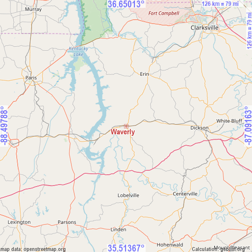
Waverly GPS coordinates[2]
36° 5' 2.22" North, 87° 47' 41.1" West
| Map corner | latitude | longitude |
|---|---|---|
| Upper-left | 36.65013°, | -88.49788° |
| Center: | 36.08395°, | -87.79475° |
| Lower-right: | 35.51367°, | -87.09163° |
| Map W x H: | 126.4×126.4 km | = 78.5×78.5mi |
| max Lat: | 71.29058° ⇑70% North |
| Waverly: | 36.08395° |
| min Lat: | ⇓30% South 19.06759° |
| min Long | Waverly | max Long |
| -171.73463° | -87.79475° | -66.98998° |
| W 48.1%⇐ | ⇒51.9% E |
Elevation
Elevation of Waverly is 161 m = 528 ft, and this is 133.8 m = 439 ft below average elevation for this country.
| Max E: |
3189 m = 10463 ft | 58.8% |
| Avg. | 294.8 m = 967 ft | |
| Waverly | 161 m = 528 ft | |
Min E: |
-60 m = -197 ft | 41.2% |
See also: United States elevation on elevation.city.
Geographical zone
Waverly is located in North temperate zone (between Tropic of Cancer and the Arctic Circle). Distance of this Northern Tropic circle is 1406.2 km =873.8 mi to South.| Distance of | km | miles | from Waverly |
|---|---|---|---|
| North Pole | 5994.9 | 3725.1 | to North |
| Arctic Circle | 3389 | 2105.8 | to North |
| Tropic Cancer | 1406.2 | 873.8 | to South |
| Equator | 4012.2 | 2493.1 | to South |


Nearby cities:
15 places around Waverly: (largest is in red/bold)
• Big Sandy
31 km =19.3 mi,  302°
302°
• Bruceton
40.7 km =25.3 mi,  262°
262°
• Burns
43.5 km =27 mi,  94°
94°
• Camden
27.4 km =17 mi, 264°
• Charlotte
42.2 km =26.2 mi,  75°
75°
• Dickson
36.6 km =22.7 mi, 91°
• Erin
27.6 km =17.1 mi,  18°
18°
• Hollow Rock
43.3 km =26.9 mi, 263°
• Johnsonville
14.5 km =9 mi, 259°
• Lobelville
34.7 km =21.6 mi,  178°
178°
• Lyles
44.4 km =27.6 mi,  114°
114°
• McEwen
14.8 km =9.2 mi, 79°
• New Johnsonville
17 km =10.6 mi,  245°
245°
• Pleasant Hill
33.9 km =21.1 mi,  279°
279°
• Tennessee Ridge
25.4 km =15.8 mi,  4°
4°
Sources, notices
• [Note1] Compared only with cities in United States existing in our database
• [Src1] Map data: © OpenStreetMap contributors (CC-BY-SA)
• [Src2] Other city data from geonames.org with taken over terms of usage.
• [Src3] Geographical zone / Annual Mean Temperature by Robert A. Rohde @ Wikipedia
