Dickson geodata
Dickson (Tennessee) is a populated place; located in United States in America/Chicago (GMT-5) time zone. With population of 15,359 people, there are 3172 cities with bigger population in this country. Compared to other cities in United States, 70.1% of cities are located further ↑North; 50.6% of cities are located further →East and 61.9% of cities have lower elevation than Dickson. Note1


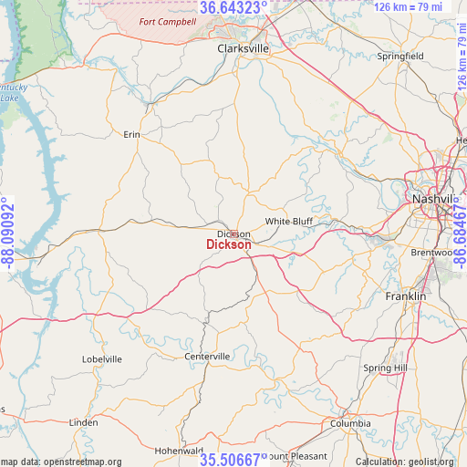
Dickson GPS coordinates[2]
36° 4' 37.2" North, 87° 23' 16.044" West
| Map corner | latitude | longitude |
|---|---|---|
| Upper-left | 36.64323°, | -88.09092° |
| Center: | 36.077°, | -87.38779° |
| Lower-right: | 35.50667°, | -86.68467° |
| Map W x H: | 126.4×126.4 km | = 78.5×78.5mi |
| max Lat: | 71.29058° ⇑70.1% North |
| Dickson: | 36.077° |
| min Lat: | ⇓29.9% South 19.06759° |
| min Long | Dickson | max Long |
| -171.73463° | -87.38779° | -66.98998° |
| W 49.4%⇐ | ⇒50.6% E |
Elevation
Elevation of Dickson is 248 m = 814 ft, and this is 46.8 m = 154 ft below average elevation for this country.
| Max E: |
3189 m = 10463 ft | 38.1% |
| Avg. | 294.8 m = 967 ft | |
| Dickson | 248 m = 814 ft | |
Min E: |
-60 m = -197 ft | 61.9% |
See also: United States elevation on elevation.city.
Geographical zone
Dickson is located in North temperate zone (between Tropic of Cancer and the Arctic Circle). Distance of this Northern Tropic circle is 1405.5 km =873.3 mi to South.| Distance of | km | miles | from Dickson |
|---|---|---|---|
| North Pole | 5995.7 | 3725.6 | to North |
| Arctic Circle | 3389.8 | 2106.3 | to North |
| Tropic Cancer | 1405.5 | 873.3 | to South |
| Equator | 4011.4 | 2492.6 | to South |


Nearby cities:
15 places around Dickson: (largest is in red/bold)
• Ashland City
36.4 km =22.6 mi,  52°
52°
• Bon Aqua Junction
18 km =11.2 mi,  157°
157°
• Burns
7.3 km =4.5 mi,  111°
111°
• Centerville
33.9 km =21.1 mi,  192°
192°
• Charlotte
12 km =7.5 mi,  21°
21°
• Erin
38.5 km =23.9 mi,  314°
314°
• Fairview
26.2 km =16.3 mi, 113°
• Kingston Springs
24.7 km =15.3 mi,  83°
83°
• Lyles
17.9 km =11.1 mi,  167°
167°
• McEwen
22.3 km =13.9 mi,  278°
278°
• Pegram
30.4 km =18.9 mi,  85°
85°
• Pleasant View
47.3 km =29.4 mi,  41°
41°
• Tennessee Ridge
43.4 km =27 mi, 307°
• Waverly
36.6 km =22.7 mi,  271°
271°
• White Bluff
15.4 km =9.6 mi, 77°
Sources, notices
• [Note1] Compared only with cities in United States existing in our database
• [Src1] Map data: © OpenStreetMap contributors (CC-BY-SA)
• [Src2] Other city data from geonames.org with taken over terms of usage.
• [Src3] Geographical zone / Annual Mean Temperature by Robert A. Rohde @ Wikipedia
