Burns geodata
Burns (Tennessee) is a populated place; located in United States in America/Chicago (GMT-5) time zone. With population of 1,473 people, there are 13779 cities with bigger population in this country. Compared to other cities in United States, 70.2% of cities are located further ↑North; 50.4% of cities are located further →East and 61.4% of cities have lower elevation than Burns. Note1


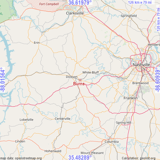
Burns GPS coordinates[2]
36° 3' 12.204" North, 87° 18' 45.036" West
| Map corner | latitude | longitude |
|---|---|---|
| Upper-left | 36.61979°, | -88.01564° |
| Center: | 36.05339°, | -87.31251° |
| Lower-right: | 35.48289°, | -86.60939° |
| Map W x H: | 126.4×126.4 km | = 78.5×78.5mi |
| max Lat: | 71.29058° ⇑70.2% North |
| Burns: | 36.05339° |
| min Lat: | ⇓29.8% South 19.06759° |
| min Long | Burns | max Long |
| -171.73463° | -87.31251° | -66.98998° |
| W 49.6%⇐ | ⇒50.4% E |
Elevation
Elevation of Burns is 246 m = 807 ft, and this is 48.8 m = 160 ft below average elevation for this country.
| Max E: |
3189 m = 10463 ft | 38.6% |
| Avg. | 294.8 m = 967 ft | |
| Burns | 246 m = 807 ft | |
Min E: |
-60 m = -197 ft | 61.4% |
See also: United States elevation on elevation.city.
Geographical zone
Burns is located in North temperate zone (between Tropic of Cancer and the Arctic Circle). Distance of this Northern Tropic circle is 1402.8 km =871.7 mi to South.| Distance of | km | miles | from Burns |
|---|---|---|---|
| North Pole | 5998.3 | 3727.2 | to North |
| Arctic Circle | 3392.4 | 2107.9 | to North |
| Tropic Cancer | 1402.8 | 871.7 | to South |
| Equator | 4008.8 | 2491 | to South |


Nearby cities:
15 places around Burns: (largest is in red/bold)
• Ashland City
33.2 km =20.6 mi,  42°
42°
• Belle Meade
41.2 km =25.6 mi,  83°
83°
• Bon Aqua Junction
14 km =8.7 mi,  179°
179°
• Centerville
33.5 km =20.8 mi,  204°
204°
• Charlotte
14 km =8.7 mi,  349°
349°
• Dickson
7.3 km =4.5 mi,  291°
291°
• Fairview
18.9 km =11.7 mi,  114°
114°
• Forest Hills
42.1 km =26.2 mi,  87°
87°
• Franklin
42.4 km =26.3 mi, 109°
• Kingston Springs
18.6 km =11.6 mi,  73°
73°
• Lyles
15.1 km =9.4 mi,  191°
191°
• McEwen
29.4 km =18.3 mi,  281°
281°
• Pegram
24.1 km =15 mi, 77°
• Waverly
43.5 km =27 mi,  274°
274°
• White Bluff
10.2 km =6.3 mi,  53°
53°
Sources, notices
• [Note1] Compared only with cities in United States existing in our database
• [Src1] Map data: © OpenStreetMap contributors (CC-BY-SA)
• [Src2] Other city data from geonames.org with taken over terms of usage.
• [Src3] Geographical zone / Annual Mean Temperature by Robert A. Rohde @ Wikipedia
