Erin geodata
Erin (Tennessee) is a seat of a second-order administrative division; located in United States in America/Chicago (GMT-5) time zone. With population of 1,295 people, there are 14610 cities with bigger population in this country. Compared to other cities in United States, 68.8% of cities are located further ↑North; 51.4% of cities are located further →East and 63.5% of cities have higher elevation than Erin. Note1


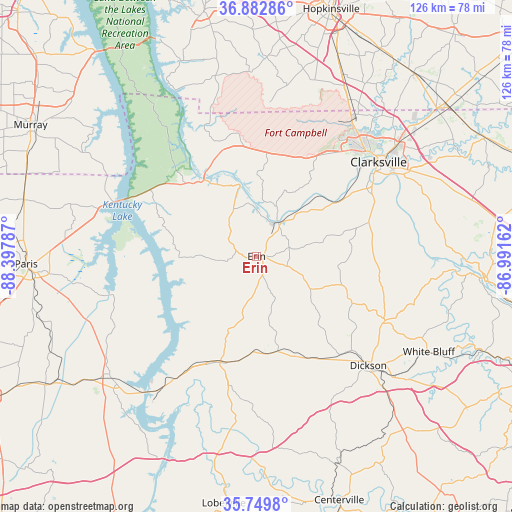
Erin GPS coordinates[2]
36° 19' 6.204" North, 87° 41' 41.064" West
| Map corner | latitude | longitude |
|---|---|---|
| Upper-left | 36.88286°, | -88.39787° |
| Center: | 36.31839°, | -87.69474° |
| Lower-right: | 35.7498°, | -86.99162° |
| Map W x H: | 126×126 km | = 78.3×78.3mi |
| max Lat: | 71.29058° ⇑68.8% North |
| Erin: | 36.31839° |
| min Lat: | ⇓31.2% South 19.06759° |
| min Long | Erin | max Long |
| -171.73463° | -87.69474° | -66.98998° |
| W 48.6%⇐ | ⇒51.4% E |
Elevation
Elevation of Erin is 136 m = 446 ft, and this is 158.8 m = 521 ft below average elevation for this country.
| Max E: |
3189 m = 10463 ft | 63.5% |
| Avg. | 294.8 m = 967 ft | |
| Erin | 136 m = 446 ft | |
Min E: |
-60 m = -197 ft | 36.5% |
See also: United States elevation on elevation.city.
Geographical zone
Erin is located in North temperate zone (between Tropic of Cancer and the Arctic Circle). Distance of this Northern Tropic circle is 1432.3 km =890 mi to South.| Distance of | km | miles | from Erin |
|---|---|---|---|
| North Pole | 5968.8 | 3708.8 | to North |
| Arctic Circle | 3362.9 | 2089.6 | to North |
| Tropic Cancer | 1432.3 | 890 | to South |
| Equator | 4038.2 | 2509.2 | to South |


Nearby cities:
15 places around Erin: (largest is in red/bold)
• Big Sandy
36.2 km =22.5 mi,  255°
255°
• Burns
45.2 km =28.1 mi,  130°
130°
• Camden
46.3 km =28.8 mi,  231°
231°
• Charlotte
35.5 km =22.1 mi,  116°
116°
• Clarksville
38.1 km =23.7 mi,  51°
51°
• Dickson
38.5 km =23.9 mi, 134°
• Dover
22.8 km =14.2 mi,  325°
325°
• Fort Campbell North
42.8 km =26.6 mi,  29°
29°
• Johnsonville
36.9 km =22.9 mi,  218°
218°
• McEwen
24.1 km =15 mi,  166°
166°
• New Johnsonville
41.1 km =25.5 mi, 216°
• Oak Grove
44.6 km =27.7 mi, 30°
• Pleasant Hill
47.1 km =29.3 mi,  244°
244°
• Tennessee Ridge
7.1 km =4.4 mi, 264°
• Waverly
27.6 km =17.1 mi,  198°
198°
Sources, notices
• [Note1] Compared only with cities in United States existing in our database
• [Src1] Map data: © OpenStreetMap contributors (CC-BY-SA)
• [Src2] Other city data from geonames.org with taken over terms of usage.
• [Src3] Geographical zone / Annual Mean Temperature by Robert A. Rohde @ Wikipedia
