Anahuac geodata
Anahuac (Texas) is a seat of a second-order administrative division; located in United States in America/Chicago (GMT-5) time zone. With population of 2,324 people, there are 11036 cities with bigger population in this country. Compared to other cities in United States, 94% of cities are located further ↑North; 70.3% of cities are located further →East and 95.7% of cities have higher elevation than Anahuac. Note1


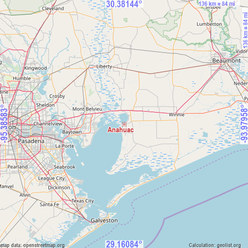
Anahuac GPS coordinates[2]
29° 46' 22.8" North, 94° 40' 57.72" West
| Map corner | latitude | longitude |
|---|---|---|
| Upper-left | 30.38144°, | -95.38583° |
| Center: | 29.773°, | -94.6827° |
| Lower-right: | 29.16084°, | -93.97958° |
| Map W x H: | 135.7×135.7 km | = 84.3×84.3mi |
| max Lat: | 71.29058° ⇑94% North |
| Anahuac: | 29.773° |
| min Lat: | ⇓6% South 19.06759° |
| min Long | Anahuac | max Long |
| -171.73463° | -94.6827° | -66.98998° |
| W 29.7%⇐ | ⇒70.3% E |
Elevation
Elevation of Anahuac is 8 m = 26 ft, and this is 286.8 m = 941 ft below average elevation for this country.
| Max E: |
3189 m = 10463 ft | 95.7% |
| Avg. | 294.8 m = 967 ft | |
| Anahuac | 8 m = 26 ft | |
Min E: |
-60 m = -197 ft | 4.3% |
See also: United States elevation on elevation.city.
Geographical zone
Anahuac is located in North temperate zone (between Tropic of Cancer and the Arctic Circle). Distance of this Northern Tropic circle is 704.5 km =437.8 mi to South.| Distance of | km | miles | from Anahuac |
|---|---|---|---|
| North Pole | 6696.6 | 4161.1 | to North |
| Arctic Circle | 4090.7 | 2541.8 | to North |
| Tropic Cancer | 704.5 | 437.8 | to South |
| Equator | 3310.4 | 2057 | to South |


Nearby cities:
15 places around Anahuac: (largest is in red/bold)
• Ames
31.8 km =19.8 mi,  349°
349°
• Baytown
28.8 km =17.9 mi,  261°
261°
• Beach City
23.5 km =14.6 mi,  238°
238°
• Bolivar Peninsula
34.2 km =21.3 mi,  163°
163°
• Cove
13 km =8.1 mi,  297°
297°
• Daisetta
38 km =23.6 mi,  5°
5°
• Dayton
36.1 km =22.4 mi,  327°
327°
• Highlands
36.4 km =22.6 mi,  278°
278°
• La Porte
34.6 km =21.5 mi,  249°
249°
• Liberty
33.5 km =20.8 mi,  341°
341°
• Mont Belvieu
21.7 km =13.5 mi,  292°
292°
• Old River-Winfree
17.9 km =11.1 mi,  306°
306°
• Shoreacres
35.9 km =22.3 mi, 241°
• Stowell
29 km =18 mi,  86°
86°
• Winnie
29.3 km =18.2 mi,  79°
79°
Sources, notices
• [Note1] Compared only with cities in United States existing in our database
• [Src1] Map data: © OpenStreetMap contributors (CC-BY-SA)
• [Src2] Other city data from geonames.org with taken over terms of usage.
• [Src3] Geographical zone / Annual Mean Temperature by Robert A. Rohde @ Wikipedia
