Cove geodata
Cove (Texas) is a populated place; located in United States in America/Chicago (GMT-5) time zone. With population of 509 people, there are 20770 cities with bigger population in this country. Compared to other cities in United States, 93.8% of cities are located further ↑North; 70.6% of cities are located further →East and 93% of cities have higher elevation than Cove. Note1


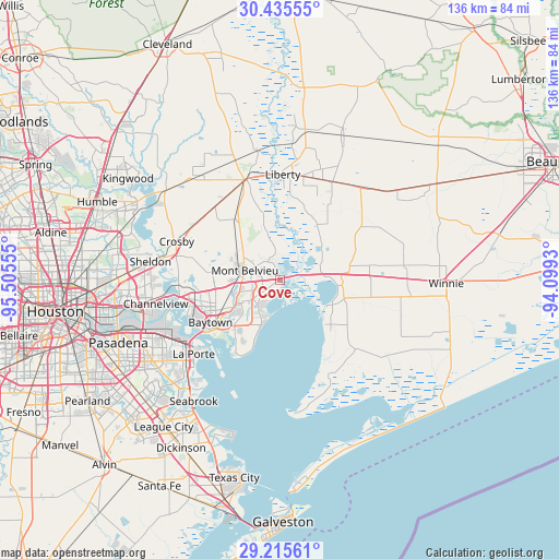
Cove GPS coordinates[2]
29° 49' 38.784" North, 94° 48' 8.712" West
| Map corner | latitude | longitude |
|---|---|---|
| Upper-left | 30.43555°, | -95.50555° |
| Center: | 29.82744°, | -94.80242° |
| Lower-right: | 29.21561°, | -94.0993° |
| Map W x H: | 135.6×135.6 km | = 84.3×84.3mi |
| max Lat: | 71.29058° ⇑93.8% North |
| Cove: | 29.82744° |
| min Lat: | ⇓6.2% South 19.06759° |
| min Long | Cove | max Long |
| -171.73463° | -94.80242° | -66.98998° |
| W 29.4%⇐ | ⇒70.6% E |
Elevation
Elevation of Cove is 11 m = 36 ft, and this is 283.8 m = 931 ft below average elevation for this country.
| Max E: |
3189 m = 10463 ft | 93% |
| Avg. | 294.8 m = 967 ft | |
| Cove | 11 m = 36 ft | |
Min E: |
-60 m = -197 ft | 7% |
See also: United States elevation on elevation.city.
Geographical zone
Cove is located in North temperate zone (between Tropic of Cancer and the Arctic Circle). Distance of this Northern Tropic circle is 710.6 km =441.5 mi to South.| Distance of | km | miles | from Cove |
|---|---|---|---|
| North Pole | 6690.6 | 4157.3 | to North |
| Arctic Circle | 4084.7 | 2538.1 | to North |
| Tropic Cancer | 710.6 | 441.5 | to South |
| Equator | 3316.5 | 2060.8 | to South |


Nearby cities:
15 places around Cove: (largest is in red/bold)
• Ames
25.8 km =16 mi,  12°
12°
• Anahuac
13 km =8.1 mi,  117°
117°
• Barrett
25.8 km =16 mi,  283°
283°
• Baytown
19.7 km =12.2 mi,  238°
238°
• Beach City
20.2 km =12.6 mi,  204°
204°
• Channelview
30.7 km =19.1 mi,  259°
259°
• Crosby
26.7 km =16.6 mi,  290°
290°
• Dayton
25.6 km =15.9 mi,  341°
341°
• Highlands
24.5 km =15.2 mi,  267°
267°
• La Porte
27.6 km =17.1 mi,  229°
229°
• Liberty
25.6 km =15.9 mi,  1°
1°
• Mont Belvieu
8.8 km =5.5 mi, 284°
• Old River-Winfree
5.4 km =3.4 mi,  327°
327°
• Sheldon
31.7 km =19.7 mi, 278°
• Shoreacres
30.5 km =19 mi,  221°
221°
Sources, notices
• [Note1] Compared only with cities in United States existing in our database
• [Src1] Map data: © OpenStreetMap contributors (CC-BY-SA)
• [Src2] Other city data from geonames.org with taken over terms of usage.
• [Src3] Geographical zone / Annual Mean Temperature by Robert A. Rohde @ Wikipedia
