Atlanta geodata
Atlanta (Texas) is a populated place; located in United States in America/Chicago (GMT-5) time zone. With population of 5,605 people, there are 6677 cities with bigger population in this country. Compared to other cities in United States, 84.7% of cities are located further ↑North; 69% of cities are located further →East and 73% of cities have higher elevation than Atlanta. Note1


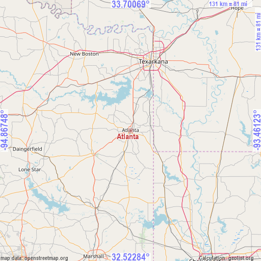
Atlanta GPS coordinates[2]
33° 6' 49.464" North, 94° 9' 51.66" West
| Map corner | latitude | longitude |
|---|---|---|
| Upper-left | 33.70069°, | -94.86748° |
| Center: | 33.11374°, | -94.16435° |
| Lower-right: | 32.52284°, | -93.46123° |
| Map W x H: | 131×131 km | = 81.4×81.4mi |
| max Lat: | 71.29058° ⇑84.7% North |
| Atlanta: | 33.11374° |
| min Lat: | ⇓15.3% South 19.06759° |
| min Long | Atlanta | max Long |
| -171.73463° | -94.16435° | -66.98998° |
| W 31%⇐ | ⇒69% E |
Elevation
Elevation of Atlanta is 83 m = 272 ft, and this is 211.8 m = 695 ft below average elevation for this country.
| Max E: |
3189 m = 10463 ft | 73% |
| Avg. | 294.8 m = 967 ft | |
| Atlanta | 83 m = 272 ft | |
Min E: |
-60 m = -197 ft | 27% |
See also: United States elevation on elevation.city.
Geographical zone
Atlanta is located in North temperate zone (between Tropic of Cancer and the Arctic Circle). Distance of this Northern Tropic circle is 1076 km =668.6 mi to South.| Distance of | km | miles | from Atlanta |
|---|---|---|---|
| North Pole | 6325.2 | 3930.3 | to North |
| Arctic Circle | 3719.3 | 2311.1 | to North |
| Tropic Cancer | 1076 | 668.6 | to South |
| Equator | 3681.9 | 2287.8 | to South |


Nearby cities:
15 places around Atlanta: (largest is in red/bold)
• Fouke
30.7 km =19.1 mi,  57°
57°
• Hooks
40.9 km =25.4 mi,  343°
343°
• Jefferson
43.1 km =26.8 mi,  203°
203°
• Linden
21.9 km =13.6 mi,  238°
238°
• Maud
29.5 km =18.3 mi,  325°
325°
• Nash
36.7 km =22.8 mi,  4°
4°
• New Boston
45 km =28 mi, 328°
• Oil City
44.9 km =27.9 mi,  156°
156°
• Queen City
4.1 km =2.5 mi,  18°
18°
• Red Lick
39 km =24.2 mi,  359°
359°
• Redwater
28.4 km =17.6 mi, 342°
• Texarkana
36.3 km =22.6 mi, 17°
• Texarkana
38.3 km =23.8 mi, 17°
• Vivian
31.6 km =19.6 mi,  148°
148°
• Wake Village
35.2 km =21.9 mi,  8°
8°
Sources, notices
• [Note1] Compared only with cities in United States existing in our database
• [Src1] Map data: © OpenStreetMap contributors (CC-BY-SA)
• [Src2] Other city data from geonames.org with taken over terms of usage.
• [Src3] Geographical zone / Annual Mean Temperature by Robert A. Rohde @ Wikipedia
