Jefferson geodata
Jefferson (Texas) is a seat of a second-order administrative division; located in United States in America/Chicago (GMT-5) time zone. With population of 2,048 people, there are 11802 cities with bigger population in this country. Compared to other cities in United States, 86.1% of cities are located further ↑North; 69.5% of cities are located further →East and 76.5% of cities have higher elevation than Jefferson. Note1


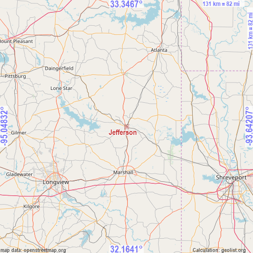
Jefferson GPS coordinates[2]
32° 45' 26.496" North, 94° 20' 42.684" West
| Map corner | latitude | longitude |
|---|---|---|
| Upper-left | 33.3467°, | -95.04832° |
| Center: | 32.75736°, | -94.34519° |
| Lower-right: | 32.1641°, | -93.64207° |
| Map W x H: | 131.5×131.5 km | = 81.7×81.7mi |
| max Lat: | 71.29058° ⇑86.1% North |
| Jefferson: | 32.75736° |
| min Lat: | ⇓13.9% South 19.06759° |
| min Long | Jefferson | max Long |
| -171.73463° | -94.34519° | -66.98998° |
| W 30.5%⇐ | ⇒69.5% E |
Elevation
Elevation of Jefferson is 63 m = 207 ft, and this is 231.8 m = 760 ft below average elevation for this country.
| Max E: |
3189 m = 10463 ft | 76.5% |
| Avg. | 294.8 m = 967 ft | |
| Jefferson | 63 m = 207 ft | |
Min E: |
-60 m = -197 ft | 23.5% |
See also: United States elevation on elevation.city.
Geographical zone
Jefferson is located in North temperate zone (between Tropic of Cancer and the Arctic Circle). Distance of this Northern Tropic circle is 1036.4 km =644 mi to South.| Distance of | km | miles | from Jefferson |
|---|---|---|---|
| North Pole | 6364.8 | 3954.9 | to North |
| Arctic Circle | 3758.9 | 2335.7 | to North |
| Tropic Cancer | 1036.4 | 644 | to South |
| Equator | 3642.3 | 2263.2 | to South |


Nearby cities:
15 places around Jefferson: (largest is in red/bold)
• Atlanta
43.1 km =26.8 mi,  23°
23°
• Blanchard
46.7 km =29 mi,  114°
114°
• Daingerfield
46.6 km =29 mi,  310°
310°
• Easton
46.8 km =29.1 mi,  208°
208°
• Hallsville
35.4 km =22 mi,  217°
217°
• Hughes Springs
37.8 km =23.5 mi,  315°
315°
• Linden
28.4 km =17.6 mi,  356°
356°
• Lone Star
39.7 km =24.7 mi,  301°
301°
• Longview
46.7 km =29 mi,  232°
232°
• Marshall
23.7 km =14.7 mi,  185°
185°
• Mooringsport
36.8 km =22.9 mi,  102°
102°
• Oil City
35 km =21.7 mi,  92°
92°
• Ore City
35.4 km =22 mi,  277°
277°
• Vivian
35.8 km =22.2 mi,  69°
69°
• Waskom
40.9 km =25.4 mi,  139°
139°
Sources, notices
• [Note1] Compared only with cities in United States existing in our database
• [Src1] Map data: © OpenStreetMap contributors (CC-BY-SA)
• [Src2] Other city data from geonames.org with taken over terms of usage.
• [Src3] Geographical zone / Annual Mean Temperature by Robert A. Rohde @ Wikipedia
