Hooks geodata
Hooks (Texas) is a populated place; located in United States in America/Chicago (GMT-5) time zone. With population of 2,744 people, there are 10097 cities with bigger population in this country. Compared to other cities in United States, 83.3% of cities are located further ↑North; 69.3% of cities are located further →East and 67.3% of cities have higher elevation than Hooks. Note1


Hooks GPS coordinates[2]
33° 27' 58.428" North, 94° 17' 18.708" West
| Map corner | latitude | longitude |
|---|---|---|
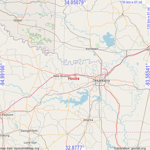
| Upper-left | 34.05079°, | -94.99166° |
| Center: | 33.46623°, | -94.28853° |
| Lower-right: | 32.8777°, | -93.58541° |
| Map W x H: | 130.4×130.4 km | = 81×81mi |
| max Lat: | 71.29058° ⇑83.3% North |
| Hooks: | 33.46623° |
| min Lat: | ⇓16.7% South 19.06759° |
| min Long | Hooks | max Long |
| -171.73463° | -94.28853° | -66.98998° |
| W 30.7%⇐ | ⇒69.3% E |
Elevation
Elevation of Hooks is 116 m = 381 ft, and this is 178.8 m = 587 ft below average elevation for this country.
| Max E: |
3189 m = 10463 ft | 67.3% |
| Avg. | 294.8 m = 967 ft | |
| Hooks | 116 m = 381 ft | |
Min E: |
-60 m = -197 ft | 32.7% |
See also: United States elevation on elevation.city.
Geographical zone
Hooks is located in North temperate zone (between Tropic of Cancer and the Arctic Circle). Distance of this Northern Tropic circle is 1115.2 km =693 mi to South.| Distance of | km | miles | from Hooks |
|---|---|---|---|
| North Pole | 6286 | 3905.9 | to North |
| Arctic Circle | 3680.1 | 2286.7 | to North |
| Tropic Cancer | 1115.2 | 693 | to South |
| Equator | 3721.1 | 2312.2 | to South |


Nearby cities:
15 places around Hooks: (largest is in red/bold)
• Ashdown
27.3 km =17 mi,  32°
32°
• Atlanta
40.9 km =25.4 mi,  163°
163°
• De Kalb
30.8 km =19.1 mi,  278°
278°
• Foreman
30.1 km =18.7 mi,  340°
340°
• Fouke
43.8 km =27.2 mi,  121°
121°
• Maud
15.7 km =9.8 mi,  198°
198°
• Naples
46.7 km =29 mi,  231°
231°
• Nash
14.9 km =9.3 mi,  100°
100°
• New Boston
11.8 km =7.3 mi,  266°
266°
• Queen City
37.6 km =23.4 mi, 159°
• Red Lick
10.9 km =6.8 mi,  90°
90°
• Redwater
12.4 km =7.7 mi,  165°
165°
• Texarkana
22.8 km =14.2 mi, 101°
• Texarkana
23.4 km =14.5 mi, 96°
• Wake Village
17.5 km =10.9 mi, 104°
Sources, notices
• [Note1] Compared only with cities in United States existing in our database
• [Src1] Map data: © OpenStreetMap contributors (CC-BY-SA)
• [Src2] Other city data from geonames.org with taken over terms of usage.
• [Src3] Geographical zone / Annual Mean Temperature by Robert A. Rohde @ Wikipedia
