Paint Rock geodata
Paint Rock (Texas) is a seat of a second-order administrative division; located in United States in America/Chicago (GMT-5) time zone. With population of 266 people, there are 20985 cities with bigger population in this country. Compared to other cities in United States, 89.6% of cities are located further ↑North; 80.7% of cities are located further →East and 87.8% of cities have lower elevation than Paint Rock. Note1


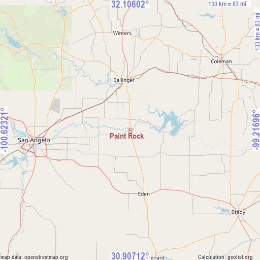
Paint Rock GPS coordinates[2]
31° 30' 30.564" North, 99° 55' 12.288" West
| Map corner | latitude | longitude |
|---|---|---|
| Upper-left | 32.10602°, | -100.62321° |
| Center: | 31.50849°, | -99.92008° |
| Lower-right: | 30.90712°, | -99.21696° |
| Map W x H: | 133.3×133.3 km | = 82.8×82.8mi |
| max Lat: | 71.29058° ⇑89.6% North |
| Paint Rock: | 31.50849° |
| min Lat: | ⇓10.4% South 19.06759° |
| min Long | Paint Rock | max Long |
| -171.73463° | -99.92008° | -66.98998° |
| W 19.3%⇐ | ⇒80.7% E |
Elevation
Elevation of Paint Rock is 499 m = 1637 ft, and this is 204.2 m = 670 ft above average elevation for this country.
| Max E: |
3189 m = 10463 ft | 12.2% |
| Paint Rock | 499 m 1637 ft | |
| Avg. | 294.8 m = 967 ft | |
Min E: |
-60 m = -197 ft | 87.8% |
See also: United States elevation on elevation.city.
Geographical zone
Paint Rock is located in North temperate zone (between Tropic of Cancer and the Arctic Circle). Distance of this Northern Tropic circle is 897.5 km =557.7 mi to South.| Distance of | km | miles | from Paint Rock |
|---|---|---|---|
| North Pole | 6503.6 | 4041.1 | to North |
| Arctic Circle | 3897.8 | 2422 | to North |
| Tropic Cancer | 897.5 | 557.7 | to South |
| Equator | 3503.4 | 2176.9 | to South |


Nearby cities:
15 places around Paint Rock: (largest is in red/bold)
• Ballinger
25.7 km =16 mi,  354°
354°
• Bangs
78.1 km =48.5 mi,  72°
72°
• Brady
69.4 km =43.1 mi,  126°
126°
• Bronte
54.9 km =34.1 mi,  320°
320°
• Carlsbad
69.4 km =43.1 mi,  278°
278°
• Christoval
65.2 km =40.5 mi,  237°
237°
• Coleman
58.6 km =36.4 mi,  52°
52°
• Eden
33.3 km =20.7 mi,  167°
167°
• Grape Creek
60 km =37.3 mi, 277°
• Menard
66.9 km =41.6 mi, 169°
• Miles
26.7 km =16.6 mi,  291°
291°
• Robert Lee
68.4 km =42.5 mi,  308°
308°
• San Angelo
49.3 km =30.6 mi,  264°
264°
• Santa Anna
62.3 km =38.7 mi, 65°
• Winters
50 km =31.1 mi,  355°
355°
Sources, notices
• [Note1] Compared only with cities in United States existing in our database
• [Src1] Map data: © OpenStreetMap contributors (CC-BY-SA)
• [Src2] Other city data from geonames.org with taken over terms of usage.
• [Src3] Geographical zone / Annual Mean Temperature by Robert A. Rohde @ Wikipedia
