Junction geodata
Junction (Texas) is a seat of a second-order administrative division; located in United States in America/Chicago (GMT-5) time zone. With population of 2,444 people, there are 10755 cities with bigger population in this country. Compared to other cities in United States, 91.8% of cities are located further ↑North; 80.6% of cities are located further →East and 88.4% of cities have lower elevation than Junction. Note1


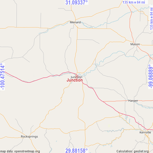
Junction GPS coordinates[2]
30° 29' 21.696" North, 99° 46' 19.236" West
| Map corner | latitude | longitude |
|---|---|---|
| Upper-left | 31.09337°, | -100.47514° |
| Center: | 30.48936°, | -99.77201° |
| Lower-right: | 29.88158°, | -99.06889° |
| Map W x H: | 134.7×134.7 km | = 83.7×83.7mi |
| max Lat: | 71.29058° ⇑91.8% North |
| Junction: | 30.48936° |
| min Lat: | ⇓8.2% South 19.06759° |
| min Long | Junction | max Long |
| -171.73463° | -99.77201° | -66.98998° |
| W 19.4%⇐ | ⇒80.6% E |
Elevation
Elevation of Junction is 522 m = 1713 ft, and this is 227.2 m = 745 ft above average elevation for this country.
| Max E: |
3189 m = 10463 ft | 11.6% |
| Junction | 522 m 1713 ft | |
| Avg. | 294.8 m = 967 ft | |
Min E: |
-60 m = -197 ft | 88.4% |
See also: United States elevation on elevation.city.
Geographical zone
Junction is located in North temperate zone (between Tropic of Cancer and the Arctic Circle). Distance of this Northern Tropic circle is 784.2 km =487.3 mi to South.| Distance of | km | miles | from Junction |
|---|---|---|---|
| North Pole | 6617 | 4111.6 | to North |
| Arctic Circle | 4011.1 | 2492.4 | to North |
| Tropic Cancer | 784.2 | 487.3 | to South |
| Equator | 3390.1 | 2106.5 | to South |


Nearby cities:
15 places around Junction: (largest is in red/bold)
• Brady
83.1 km =51.6 mi,  30°
30°
• Camp Wood
94.1 km =58.5 mi,  194°
194°
• Comfort
101.5 km =63.1 mi,  124°
124°
• Eden
81.1 km =50.4 mi,  355°
355°
• Eldorado
89.4 km =55.6 mi,  297°
297°
• Fredericksburg
89.6 km =55.7 mi,  105°
105°
• Harper
54.8 km =34.1 mi, 112°
• Ingram
68.6 km =42.6 mi,  131°
131°
• Kerrville
78.1 km =48.5 mi, 129°
• Leakey
84.6 km =52.6 mi,  179°
179°
• Mason
59.3 km =36.8 mi,  60°
60°
• Medina
92.1 km =57.2 mi,  146°
146°
• Menard
47.6 km =29.6 mi, 358°
• Rocksprings
67.1 km =41.7 mi,  218°
218°
• Sonora
83.9 km =52.1 mi,  275°
275°
Sources, notices
• [Note1] Compared only with cities in United States existing in our database
• [Src1] Map data: © OpenStreetMap contributors (CC-BY-SA)
• [Src2] Other city data from geonames.org with taken over terms of usage.
• [Src3] Geographical zone / Annual Mean Temperature by Robert A. Rohde @ Wikipedia
