Breckenridge geodata
Breckenridge (Texas) is a seat of a second-order administrative division; located in United States in America/Chicago (GMT-5) time zone. With population of 5,590 people, there are 6688 cities with bigger population in this country. Compared to other cities in United States, 86.2% of cities are located further ↑North; 79.8% of cities are located further →East and 81.6% of cities have lower elevation than Breckenridge. Note1


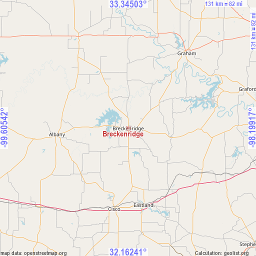
Breckenridge GPS coordinates[2]
32° 45' 20.448" North, 98° 54' 8.244" West
| Map corner | latitude | longitude |
|---|---|---|
| Upper-left | 33.34503°, | -99.60542° |
| Center: | 32.75568°, | -98.90229° |
| Lower-right: | 32.16241°, | -98.19917° |
| Map W x H: | 131.5×131.5 km | = 81.7×81.7mi |
| max Lat: | 71.29058° ⇑86.2% North |
| Breckenridge: | 32.75568° |
| min Lat: | ⇓13.8% South 19.06759° |
| min Long | Breckenridge | max Long |
| -171.73463° | -98.90229° | -66.98998° |
| W 20.2%⇐ | ⇒79.8% E |
Elevation
Elevation of Breckenridge is 372 m = 1220 ft, and this is 77.2 m = 253 ft above average elevation for this country.
| Max E: |
3189 m = 10463 ft | 18.4% |
| Breckenridge | 372 m 1220 ft | |
| Avg. | 294.8 m = 967 ft | |
Min E: |
-60 m = -197 ft | 81.6% |
See also: United States elevation on elevation.city.
Geographical zone
Breckenridge is located in North temperate zone (between Tropic of Cancer and the Arctic Circle). Distance of this Northern Tropic circle is 1036.2 km =643.9 mi to South.| Distance of | km | miles | from Breckenridge |
|---|---|---|---|
| North Pole | 6365 | 3955 | to North |
| Arctic Circle | 3759.1 | 2335.8 | to North |
| Tropic Cancer | 1036.2 | 643.9 | to South |
| Equator | 3642.1 | 2263.1 | to South |


Nearby cities:
15 places around Breckenridge: (largest is in red/bold)
• Albany
37.1 km =23.1 mi,  264°
264°
• Baird
61.2 km =38 mi,  228°
228°
• Bryson
66 km =41 mi,  46°
46°
• Cisco
41.5 km =25.8 mi,  190°
190°
• Clyde
67.7 km =42.1 mi, 234°
• Eastland
40.2 km =25 mi,  168°
168°
• Gorman
64.1 km =39.8 mi,  160°
160°
• Graford
64.5 km =40.1 mi,  71°
71°
• Graham
48.8 km =30.3 mi,  36°
36°
• Newcastle
51.1 km =31.8 mi,  17°
17°
• Olney
69.8 km =43.4 mi,  11°
11°
• Palo Pinto
56.5 km =35.1 mi,  88°
88°
• Ranger
38 km =23.6 mi,  146°
146°
• Strawn
44.1 km =27.4 mi,  120°
120°
• Throckmorton
53.6 km =33.3 mi,  331°
331°
Sources, notices
• [Note1] Compared only with cities in United States existing in our database
• [Src1] Map data: © OpenStreetMap contributors (CC-BY-SA)
• [Src2] Other city data from geonames.org with taken over terms of usage.
• [Src3] Geographical zone / Annual Mean Temperature by Robert A. Rohde @ Wikipedia
