Albany geodata
Albany (Texas) is a seat of a second-order administrative division; located in United States in America/Chicago (GMT-5) time zone. With population of 2,014 people, there are 11906 cities with bigger population in this country. Compared to other cities in United States, 86.3% of cities are located further ↑North; 80.2% of cities are located further →East and 85.5% of cities have lower elevation than Albany. Note1


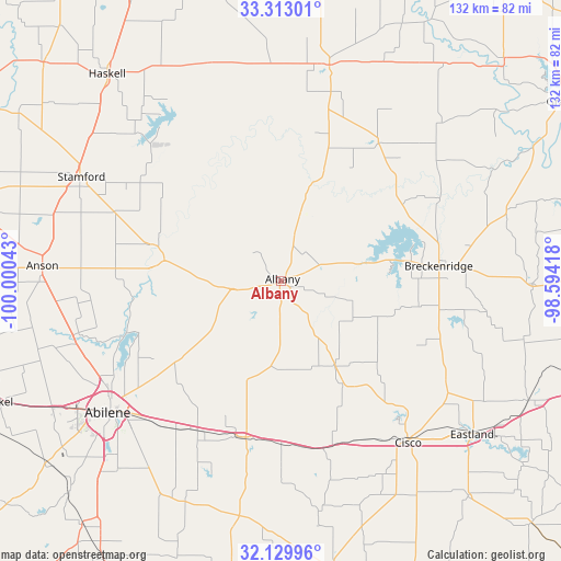
Albany GPS coordinates[2]
32° 43' 24.42" North, 99° 17' 50.28" West
| Map corner | latitude | longitude |
|---|---|---|
| Upper-left | 33.31301°, | -100.00043° |
| Center: | 32.72345°, | -99.2973° |
| Lower-right: | 32.12996°, | -98.59418° |
| Map W x H: | 131.5×131.5 km | = 81.7×81.7mi |
| max Lat: | 71.29058° ⇑86.3% North |
| Albany: | 32.72345° |
| min Lat: | ⇓13.7% South 19.06759° |
| min Long | Albany | max Long |
| -171.73463° | -99.2973° | -66.98998° |
| W 19.8%⇐ | ⇒80.2% E |
Elevation
Elevation of Albany is 434 m = 1424 ft, and this is 139.2 m = 457 ft above average elevation for this country.
| Max E: |
3189 m = 10463 ft | 14.5% |
| Albany | 434 m 1424 ft | |
| Avg. | 294.8 m = 967 ft | |
Min E: |
-60 m = -197 ft | 85.5% |
See also: United States elevation on elevation.city.
Geographical zone
Albany is located in North temperate zone (between Tropic of Cancer and the Arctic Circle). Distance of this Northern Tropic circle is 1032.6 km =641.6 mi to South.| Distance of | km | miles | from Albany |
|---|---|---|---|
| North Pole | 6368.6 | 3957.3 | to North |
| Arctic Circle | 3762.7 | 2338 | to North |
| Tropic Cancer | 1032.6 | 641.6 | to South |
| Equator | 3638.5 | 2260.9 | to South |


Nearby cities:
15 places around Albany: (largest is in red/bold)
• Abilene
51 km =31.7 mi,  233°
233°
• Anson
56.1 km =34.9 mi,  273°
273°
• Baird
37.7 km =23.4 mi,  193°
193°
• Breckenridge
37.1 km =23.1 mi,  84°
84°
• Cisco
47.7 km =29.6 mi,  141°
141°
• Clyde
39.8 km =24.7 mi,  207°
207°
• Cross Plains
67.5 km =41.9 mi,  169°
169°
• Eastland
57.5 km =35.7 mi,  128°
128°
• Haskell
63.2 km =39.3 mi,  319°
319°
• Hawley
49.9 km =31 mi,  255°
255°
• Potosi
55.3 km =34.4 mi,  217°
217°
• Ranger
64.4 km =40 mi,  115°
115°
• Stamford
53.3 km =33.1 mi,  297°
297°
• Throckmorton
51.8 km =32.2 mi,  12°
12°
• Tye
61.4 km =38.2 mi,  241°
241°
Sources, notices
• [Note1] Compared only with cities in United States existing in our database
• [Src1] Map data: © OpenStreetMap contributors (CC-BY-SA)
• [Src2] Other city data from geonames.org with taken over terms of usage.
• [Src3] Geographical zone / Annual Mean Temperature by Robert A. Rohde @ Wikipedia
