Clyde geodata
Clyde (Texas) is a populated place; located in United States in America/Chicago (GMT-5) time zone. With population of 3,771 people, there are 8498 cities with bigger population in this country. Compared to other cities in United States, 87.5% of cities are located further ↑North; 80.4% of cities are located further →East and 89.8% of cities have lower elevation than Clyde. Note1


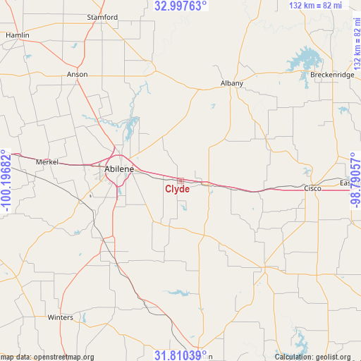
Clyde GPS coordinates[2]
32° 24' 21.456" North, 99° 29' 37.284" West
| Map corner | latitude | longitude |
|---|---|---|
| Upper-left | 32.99763°, | -100.19682° |
| Center: | 32.40596°, | -99.49369° |
| Lower-right: | 31.81039°, | -98.79057° |
| Map W x H: | 132×132 km | = 82×82mi |
| max Lat: | 71.29058° ⇑87.5% North |
| Clyde: | 32.40596° |
| min Lat: | ⇓12.5% South 19.06759° |
| min Long | Clyde | max Long |
| -171.73463° | -99.49369° | -66.98998° |
| W 19.6%⇐ | ⇒80.4% E |
Elevation
Elevation of Clyde is 608 m = 1995 ft, and this is 313.2 m = 1028 ft above average elevation for this country.
| Max E: |
3189 m = 10463 ft | 10.2% |
| Clyde | 608 m 1995 ft | |
| Avg. | 294.8 m = 967 ft | |
Min E: |
-60 m = -197 ft | 89.8% |
See also: United States elevation on elevation.city.
Geographical zone
Clyde is located in North temperate zone (between Tropic of Cancer and the Arctic Circle). Distance of this Northern Tropic circle is 997.3 km =619.7 mi to South.| Distance of | km | miles | from Clyde |
|---|---|---|---|
| North Pole | 6403.9 | 3979.2 | to North |
| Arctic Circle | 3798 | 2360 | to North |
| Tropic Cancer | 997.3 | 619.7 | to South |
| Equator | 3603.2 | 2238.9 | to South |


Nearby cities:
15 places around Clyde: (largest is in red/bold)
• Abilene
23 km =14.3 mi,  281°
281°
• Albany
39.8 km =24.7 mi,  27°
27°
• Anson
54.2 km =33.7 mi,  315°
315°
• Baird
9.4 km =5.8 mi,  98°
98°
• Cisco
48.3 km =30 mi,  92°
92°
• Coleman
64.6 km =40.1 mi,  174°
174°
• Cross Plains
43.8 km =27.2 mi,  135°
135°
• Eastland
63.5 km =39.5 mi, 90°
• Hawley
37.8 km =23.5 mi,  307°
307°
• Merkel
49.2 km =30.6 mi, 278°
• Potosi
17.5 km =10.9 mi,  240°
240°
• Rising Star
60.6 km =37.7 mi,  124°
124°
• Tuscola
35.9 km =22.3 mi,  232°
232°
• Tye
35.9 km =22.3 mi, 279°
• Winters
66.6 km =41.4 mi,  221°
221°
Sources, notices
• [Note1] Compared only with cities in United States existing in our database
• [Src1] Map data: © OpenStreetMap contributors (CC-BY-SA)
• [Src2] Other city data from geonames.org with taken over terms of usage.
• [Src3] Geographical zone / Annual Mean Temperature by Robert A. Rohde @ Wikipedia
