Brownsboro geodata
Brownsboro (Texas) is a populated place; located in United States in America/Chicago (GMT-5) time zone. With population of 1,073 people, there are 15830 cities with bigger population in this country. Compared to other cities in United States, 87.8% of cities are located further ↑North; 72.6% of cities are located further →East and 66.2% of cities have higher elevation than Brownsboro. Note1


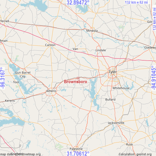
Brownsboro GPS coordinates[2]
32° 18' 8.532" North, 95° 36' 48.852" West
| Map corner | latitude | longitude |
|---|---|---|
| Upper-left | 32.89472°, | -96.3167° |
| Center: | 32.30237°, | -95.61357° |
| Lower-right: | 31.70612°, | -94.91045° |
| Map W x H: | 132.2×132.2 km | = 82.1×82.1mi |
| max Lat: | 71.29058° ⇑87.8% North |
| Brownsboro: | 32.30237° |
| min Lat: | ⇓12.2% South 19.06759° |
| min Long | Brownsboro | max Long |
| -171.73463° | -95.61357° | -66.98998° |
| W 27.4%⇐ | ⇒72.6% E |
Elevation
Elevation of Brownsboro is 122 m = 400 ft, and this is 172.8 m = 567 ft below average elevation for this country.
| Max E: |
3189 m = 10463 ft | 66.2% |
| Avg. | 294.8 m = 967 ft | |
| Brownsboro | 122 m = 400 ft | |
Min E: |
-60 m = -197 ft | 33.8% |
See also: United States elevation on elevation.city.
Geographical zone
Brownsboro is located in North temperate zone (between Tropic of Cancer and the Arctic Circle). Distance of this Northern Tropic circle is 985.8 km =612.5 mi to South.| Distance of | km | miles | from Brownsboro |
|---|---|---|---|
| North Pole | 6415.4 | 3986.3 | to North |
| Arctic Circle | 3809.5 | 2367.1 | to North |
| Tropic Cancer | 985.8 | 612.5 | to South |
| Equator | 3591.7 | 2231.8 | to South |


Nearby cities:
15 places around Brownsboro: (largest is in red/bold)
• Athens
25.2 km =15.7 mi,  244°
244°
• Berryville
27.3 km =17 mi,  150°
150°
• Bullard
33 km =20.5 mi,  123°
123°
• Canton
36.7 km =22.8 mi,  320°
320°
• Chandler
12.6 km =7.8 mi,  87°
87°
• Eustace
36.9 km =22.9 mi,  270°
270°
• Frankston
29.5 km =18.3 mi,  160°
160°
• Hideaway
25.5 km =15.8 mi,  35°
35°
• Lindale
30.5 km =19 mi, 38°
• Log Cabin
39.4 km =24.5 mi,  256°
256°
• Murchison
13.1 km =8.1 mi, 258°
• Noonday
20.9 km =13 mi,  110°
110°
• Tyler
29.9 km =18.6 mi,  79°
79°
• Van
24.8 km =15.4 mi,  354°
354°
• Whitehouse
37.4 km =23.2 mi,  102°
102°
Sources, notices
• [Note1] Compared only with cities in United States existing in our database
• [Src1] Map data: © OpenStreetMap contributors (CC-BY-SA)
• [Src2] Other city data from geonames.org with taken over terms of usage.
• [Src3] Geographical zone / Annual Mean Temperature by Robert A. Rohde @ Wikipedia
