Chandler geodata
Chandler (Texas) is a populated place; located in United States in America/Chicago (GMT-5) time zone. With population of 2,949 people, there are 9720 cities with bigger population in this country. Compared to other cities in United States, 87.8% of cities are located further ↑North; 72.3% of cities are located further →East and 65.6% of cities have higher elevation than Chandler. Note1


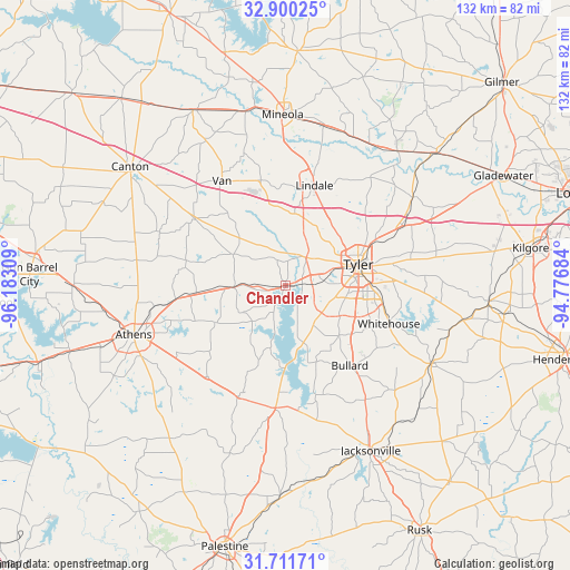
Chandler GPS coordinates[2]
32° 18' 28.548" North, 95° 28' 47.856" West
| Map corner | latitude | longitude |
|---|---|---|
| Upper-left | 32.90025°, | -96.18309° |
| Center: | 32.30793°, | -95.47996° |
| Lower-right: | 31.71171°, | -94.77684° |
| Map W x H: | 132.2×132.2 km | = 82.1×82.1mi |
| max Lat: | 71.29058° ⇑87.8% North |
| Chandler: | 32.30793° |
| min Lat: | ⇓12.2% South 19.06759° |
| min Long | Chandler | max Long |
| -171.73463° | -95.47996° | -66.98998° |
| W 27.7%⇐ | ⇒72.3% E |
Elevation
Elevation of Chandler is 125 m = 410 ft, and this is 169.8 m = 557 ft below average elevation for this country.
| Max E: |
3189 m = 10463 ft | 65.6% |
| Avg. | 294.8 m = 967 ft | |
| Chandler | 125 m = 410 ft | |
Min E: |
-60 m = -197 ft | 34.4% |
See also: United States elevation on elevation.city.
Geographical zone
Chandler is located in North temperate zone (between Tropic of Cancer and the Arctic Circle). Distance of this Northern Tropic circle is 986.4 km =612.9 mi to South.| Distance of | km | miles | from Chandler |
|---|---|---|---|
| North Pole | 6414.8 | 3986 | to North |
| Arctic Circle | 3808.9 | 2366.7 | to North |
| Tropic Cancer | 986.4 | 612.9 | to South |
| Equator | 3592.3 | 2232.2 | to South |


Nearby cities:
15 places around Chandler: (largest is in red/bold)
• Athens
37.1 km =23.1 mi,  252°
252°
• Berryville
24.4 km =15.2 mi,  178°
178°
• Brownsboro
12.6 km =7.8 mi,  267°
267°
• Bullard
24 km =14.9 mi,  141°
141°
• Frankston
28.5 km =17.7 mi,  185°
185°
• Hideaway
20.4 km =12.7 mi,  5°
5°
• Lindale
24 km =14.9 mi,  15°
15°
• Murchison
25.6 km =15.9 mi,  262°
262°
• New Chapel Hill
28.8 km =17.9 mi,  90°
90°
• Noonday
10.6 km =6.6 mi, 139°
• Troup
38.4 km =23.9 mi,  118°
118°
• Tyler
17.5 km =10.9 mi,  74°
74°
• Van
28.3 km =17.6 mi,  328°
328°
• Whitehouse
25.6 km =15.9 mi,  110°
110°
• Winona
35.6 km =22.1 mi,  55°
55°
Sources, notices
• [Note1] Compared only with cities in United States existing in our database
• [Src1] Map data: © OpenStreetMap contributors (CC-BY-SA)
• [Src2] Other city data from geonames.org with taken over terms of usage.
• [Src3] Geographical zone / Annual Mean Temperature by Robert A. Rohde @ Wikipedia
